File:2005UKElectionNominalMap.svg

Size of this PNG preview of this SVG file: 614 × 600 pixels. Other resolutions: 246 × 240 pixels | 492 × 480 pixels | 787 × 768 pixels | 1,049 × 1,024 pixels | 1,020 × 996 pixels.
Original file (SVG file, nominally 1,020 × 996 pixels, file size: 7.73 MB)
| This is a file from the Wikimedia Commons. The description on its description page there is shown below.
|
Summary
| Description |
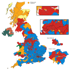
English: Map of the nominal results of the 2005 UK general election, if it had taken place with the new constituency boundaries.
Created in Inkscape. The nominal results are from Rallings and Thrasher.
Red : Labour |
| Source | Own work |
| Author | Wereon |
Licensing
| I, the copyright holder of this work, release this work into the public domain. This applies worldwide. In some countries this may not be legally possible; if so: I grant anyone the right to use this work for any purpose, without any conditions, unless such conditions are required by law. |
File history
Click on a date/time to view the file as it appeared at that time.
| Date/Time | Dimensions | User | Comment | |
|---|---|---|---|---|
| current | 16:02, 12 April 2019 | 1,020 × 996 (7.73 MB) | The- | Fixed colours |
File usage
The following 2 pages use this file: