File:215 Miles from Southport - geograph.org.uk - 515415.jpg
No higher resolution available.
215_Miles_from_Southport_-_geograph.org.uk_-_515415.jpg (640 × 452 pixels, file size: 79 KB, MIME type: image/jpeg)
| This is a file from the Wikimedia Commons. The description on its description page there is shown below.
|
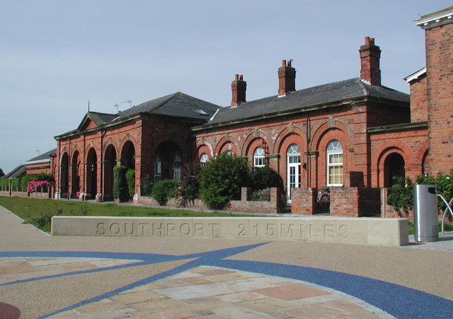
This is a photo of listed building number 1249389. |
Summary
| Description |
English: 215 Miles from Southport, Hornsea, East Riding of Yorkshire, England. Part of the installation at the old Hornsea Railway Station marking the end of the Trans Pennine Trail. The trail which runs for 215 miles from Hornsea to Southport officially opened in September 2001 after twelve years of planning and development. There are actually three locations in Hornsea where the eastern end of the trail is marked: as well as this one there is a tall metallic sculpture on the seafront and also a small and rather dull concrete plinth outside Hornsea Leisure Centre on Sands Lane. In 1846 the York & North Midland Railway Co. was granted permission to build a railway line from Beverley to Hornsea, and in 1861 Joseph Armytage Wade promoted the building of a line from Hornsea to Hull and the Hull & Hornsea Railway Co. was formed. The line opened in 1864 with this station close to the sea and another at Hornsea Bridge at the junction of Southgate and Rolston Road. After little or no financial success the company merged with North Eastern Railway in 1866. The seafront terminus closed in 1964 and Hornsea Bridge Station the following year. Hornsea Bridge Station has been demolished and the buildings here at the terminus converted into housing. |
| Date | |
| Source | From geograph.org.uk |
| Author | Paul Glazzard |
| Permission (Reusing this file) |
Creative Commons Attribution Share-alike license 2.0 |
| Attribution (required by the license) | Paul Glazzard / 215 Miles from Southport / |
| Camera location | | View this and other nearby images on: OpenStreetMap |
|---|
_heading:225.00&language=en)
| Object location | | View this and other nearby images on: OpenStreetMap |
|---|
_heading:225.00&language=en)
Licensing

|
This image was taken from the Geograph project collection. See this photograph's page on the Geograph website for the photographer's contact details. The copyright on this image is owned by Paul Glazzard and is licensed for reuse under the Creative Commons Attribution-ShareAlike 2.0 license.
|
This file is licensed under the Creative Commons Attribution-Share Alike 2.0 Generic license.
Attribution: Paul Glazzard
- You are free:
- to share – to copy, distribute and transmit the work
- to remix – to adapt the work
- Under the following conditions:
- attribution – You must give appropriate credit, provide a link to the license, and indicate if changes were made. You may do so in any reasonable manner, but not in any way that suggests the licensor endorses you or your use.
- share alike – If you remix, transform, or build upon the material, you must distribute your contributions under the same or compatible license as the original.
File history
Click on a date/time to view the file as it appeared at that time.
| Date/Time | Dimensions | User | Comment | |
|---|---|---|---|---|
| current | 04:49, 5 February 2011 | 640 × 452 (79 KB) | GeographBot | == {{int:filedesc}} == {{Information |description={{en|1=215 Miles from Southport Part of the installation at the old Hornsea Railway Station marking the end of the Trans Pennine Trail. The trail which runs for 215 miles from Hornsea to Southport official |
File usage
The following page uses this file: