File:27th amendment ratification.svg

Size of this PNG preview of this SVG file: 800 × 495 pixels. Other resolutions: 320 × 198 pixels | 640 × 396 pixels | 1,024 × 633 pixels | 1,280 × 791 pixels | 959 × 593 pixels.
Original file (SVG file, nominally 959 × 593 pixels, file size: 89 KB)
| This is a file from the Wikimedia Commons. The description on its description page there is shown below.
|
| Description |
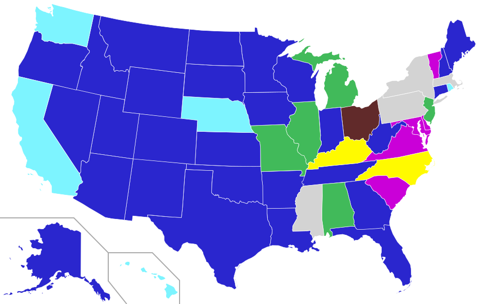
English (en): Ratification of the 27th Amendment of the United States Constitution
Ratified amendment, 1789–92 Ratified amendment, 1873 Ratified amendment, 1978–91 Ratified amendment, May 1992 1 Ratified post-enactment, 1992 to present Ratified twice (NC: 1789/1989; KY: 1792/1996) Didn't ratify amendment
1The Archivist did not certify the amendment until May 18, 1992, with 40 states listed as ratifying the amendment. Kentucky's then-forgotten 1792 ratification would have made it 41 states that had ratified at the time of certification, 3 more than the 38 required for a three-quarters majority.
|
| Date | (UTC) |
| Source | |
| Author |
I, the copyright holder of this work, hereby publish it under the following licenses:
| This file is licensed under the Creative Commons Attribution-Share Alike 3.0 Unported license. | ||
| ||
| This licensing tag was added to this file as part of the GFDL licensing update. |

|
Permission is granted to copy, distribute and/or modify this document under the terms of the GNU Free Documentation License, Version 1.2 or any later version published by the Free Software Foundation; with no Invariant Sections, no Front-Cover Texts, and no Back-Cover Texts. A copy of the license is included in the section entitled GNU Free Documentation License. |
You may select the license of your choice.
Original upload log
This image is a derivative work of the following images:
- File:Blank_US_Map.svg licensed with Cc-by-sa-3.0-migrated, GFDL
- 2009-11-05T19:44:02Z NuclearVacuum 959x593 (91518 Bytes) minor fix from previous upload
- 2009-11-05T19:39:42Z NuclearVacuum 959x593 (88399 Bytes) Fixed up the borders so they are connected with each state and loosing that gap between them.
- 2008-10-09T16:36:40Z Howcheng 959x593 (80121 Bytes) Reverted to version as of 08:32, 14 June 2007
- 2008-03-12T00:20:02Z AMK1211 959x593 (174744 Bytes) Added borders: Light blue for water borders and black for land borders (international borders thicker).
- 2007-06-14T08:32:47Z Fibonacci 959x593 (80121 Bytes) Optimised code.
- 2006-07-12T23:00:30Z Theshibboleth 959x593 (90537 Bytes) The line framework around Alaska and Hawaii has been pushed a bit
- 2006-07-12T06:35:19Z Theshibboleth 959x593 (89828 Bytes) added DC
- 2006-07-12T06:05:05Z Theshibboleth 959x593 (89649 Bytes) {{Information |Description=A blank map of the United States in scalable vector form. |Source=Own work, based on [[:Image:Electorial map.svg]], inspired by [[:Image:BlankMap-World.png]] |Date=11 July 2006 |Author=[[User:Theshi
File history
Click on a date/time to view the file as it appeared at that time.
| Date/Time | Dimensions | User | Comment | |
|---|---|---|---|---|
| current | 17:59, 10 May 2016 | 959 × 593 (89 KB) | SnowFire | Update Nebraska to ratified. |
File usage
The following page uses this file: