File:Addison Municipal Airport.jpg

Size of this preview: 600 × 600 pixels. Other resolutions: 240 × 240 pixels | 480 × 480 pixels | 997 × 997 pixels.
Original file (997 × 997 pixels, file size: 307 KB, MIME type: image/jpeg)
| This is a file from the Wikimedia Commons. The description on its description page there is shown below.
|
Summary
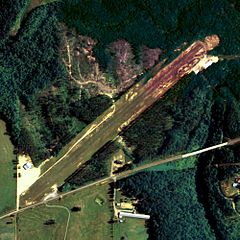
| Description | Aerial image of Addison Municipal Airport in Addison, Alabama, United States |
| Date | |
| Source | National Agriculture Imagery Program (NAIP) Orthoimagery for Zone 16 Alabama State Quarter Quadrangle ADDISON, NE and I.D. # n_3408755_ne_16_1_20060623.tif |
| Author | United States Department of Agriculture, Farm Services Agency |
| Permission (Reusing this file) |
Public domain |
Licensing
This image or file is a work of a United States Department of Agriculture employee, taken or made as part of that person's official duties. As a work of the U.S. federal government, the image is in the public domain.
|
 |
File history
Click on a date/time to view the file as it appeared at that time.
| Date/Time | Dimensions | User | Comment | |
|---|---|---|---|---|
| current | 21:58, 11 June 2009 | 997 × 997 (307 KB) | AuburnPilot | == Summary == {{Information |Description=Satellite image of Addison Municipal Airport in Addison, Alabama USA on 23 June 2006 |Source=United States Geological Survey (National Agriculture Imagery Program (NAIP) Orthoimage |
File usage
The following page uses this file: