File:African Map in 1840.jpg

Size of this preview: 757 × 600 pixels. Other resolutions: 303 × 240 pixels | 606 × 480 pixels | 970 × 768 pixels | 1,192 × 944 pixels.
Original file (1,192 × 944 pixels, file size: 1.87 MB, MIME type: image/jpeg)
| This is a file from the Wikimedia Commons. The description on its description page there is shown below.
|
| Description |
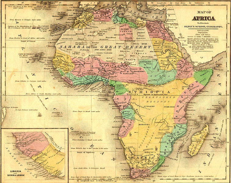
English: African Map before the 1884 Berlin Conference to divide Africa. |
| Date | |
| Source |
Original publication: 1843 |
| Author |
University of Florida Map and Imagery Library - Africa |
This work is in the public domain in the United States because it was published (or registered with the U.S. Copyright Office) before January 1, 1929.
Public domain works must be out of copyright in both the United States and in the source country of the work in order to be hosted on the Commons. If the work is not a U.S. work, the file must have an additional copyright tag indicating the copyright status in the source country.
Note: This tag should not be used for sound recordings. |
File history
Click on a date/time to view the file as it appeared at that time.
| Date/Time | Dimensions | User | Comment | |
|---|---|---|---|---|
| current | 08:10, 20 August 2015 | 1,192 × 944 (1.87 MB) | EthiopianHabesha | {{subst:Upload marker added by en.wp UW}} {{Information |Description = {{en|African Map before the 1884 Berlin Conference to divide Africa.}} |Source = '''Original publication''': 1843<br/> '''Immediate source''': http://www.themapdatabase.com/1843/10/... |
File usage
The following page uses this file: