File:Annapurna Massif Aerial View.jpg

Size of this preview: 800 × 374 pixels. Other resolutions: 320 × 150 pixels | 640 × 300 pixels | 1,024 × 479 pixels | 1,280 × 599 pixels | 3,205 × 1,500 pixels.
Original file (3,205 × 1,500 pixels, file size: 1.51 MB, MIME type: image/jpeg)
| This is a file from the Wikimedia Commons. The description on its description page there is shown below.
|
Summary
| Camera location | | View this and other nearby images on: OpenStreetMap |
|---|
| Description |
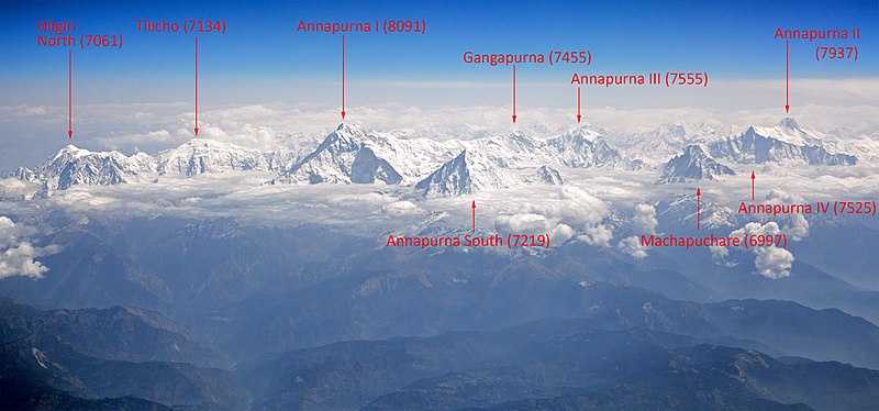
English: Annapurna Massif, view from aircraft Русский: Аннапурна, вид с самолёта |
| Date | |
| Source | Own work |
| Author | Solundir |
| Other versions |
Licensing
I, the copyright holder of this work, hereby publish it under the following license:
This file is licensed under the Creative Commons Attribution-Share Alike 3.0 Unported license.
- You are free:
- to share – to copy, distribute and transmit the work
- to remix – to adapt the work
- Under the following conditions:
- attribution – You must give appropriate credit, provide a link to the license, and indicate if changes were made. You may do so in any reasonable manner, but not in any way that suggests the licensor endorses you or your use.
- share alike – If you remix, transform, or build upon the material, you must distribute your contributions under the same or compatible license as the original.
File history
Click on a date/time to view the file as it appeared at that time.
| Date/Time | Dimensions | User | Comment | |
|---|---|---|---|---|
| current | 11:06, 10 December 2011 | 3,205 × 1,500 (1.51 MB) | Solundir |
File usage
The following 2 pages use this file: