File:Anser anser distribution map.png

Size of this preview: 800 × 383 pixels. Other resolutions: 320 × 153 pixels | 640 × 306 pixels | 1,422 × 680 pixels.
Original file (1,422 × 680 pixels, file size: 86 KB, MIME type: image/png)
| This is a file from the Wikimedia Commons. The description on its description page there is shown below.
|
Summary
| Description |
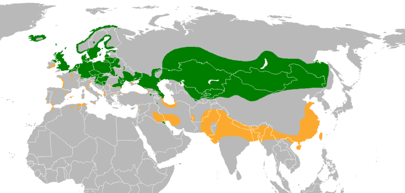
Español: Área de distribución del ganso común (Anser anser).
Clave de color: 007e00 - zona de cría; fbaa2f - zona de invernada; ff0000 - introducido. English: Anser anser range map.
Color key; 007e00 - breeding; fbaa2f - non breeding, ff0000 - introduced. |
| Date | |
| Source | Own work |
| Author | Osado |
Data source: IUCN Range Map
Licensing
I, the copyright holder of this work, hereby publish it under the following license:
This file is licensed under the Creative Commons Attribution-Share Alike 4.0 International license.
- You are free:
- to share – to copy, distribute and transmit the work
- to remix – to adapt the work
- Under the following conditions:
- attribution – You must give appropriate credit, provide a link to the license, and indicate if changes were made. You may do so in any reasonable manner, but not in any way that suggests the licensor endorses you or your use.
- share alike – If you remix, transform, or build upon the material, you must distribute your contributions under the same or compatible license as the original.
File history
Click on a date/time to view the file as it appeared at that time.
| Date/Time | Dimensions | User | Comment | |
|---|---|---|---|---|
| current | 15:59, 20 June 2022 | 1,422 × 680 (86 KB) | MPF | Improve accuracy in Europe from EBCC2 Atlas; crop Australia (feral domesticated birds occur worldwide, not restricted to Australia) |
File usage
The following page uses this file: