File:April 2010 Baja California earthquake intensity USGS.jpg

Size of this preview: 511 × 600 pixels. Other resolutions: 204 × 240 pixels | 612 × 718 pixels.
Original file (612 × 718 pixels, file size: 123 KB, MIME type: image/jpeg)
| This is a file from the Wikimedia Commons. The description on its description page there is shown below.
|
Summary
| Description |
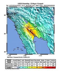
English: Shake map of the magnitude 7.2 earthquake occurring at Baja California, Mexico on April 4, 2010. Epicenter marked at star. Realized by USGS on April 4, 2010. |
|||
| Date | ||||
| Source | USGS | |||
| Author | USGS | |||
| Permission (Reusing this file) |
|
File history
Click on a date/time to view the file as it appeared at that time.
| Date/Time | Dimensions | User | Comment | |
|---|---|---|---|---|
| current | 12:46, 30 January 2020 | 612 × 718 (123 KB) | Tinh1000000 | ATLAS 2018-03-12 revision |
File usage
The following page uses this file: