File:Atlantic-city-nj-map.png
No higher resolution available.
Atlantic-city-nj-map.png (575 × 425 pixels, file size: 47 KB, MIME type: image/png)
| This is a file from the Wikimedia Commons. The description on its description page there is shown below.
|
Summary
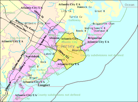
| Description | U.S. Census 2000 reference map for Atlantic City, New Jersey |
| Date | |
| Source | http://factfinder.census.gov |
| Author | United States Census Bureau |
| Permission (Reusing this file) |
Public domain |
Licensing
This image or file is a work of a United States Census Bureau employee, taken or made as part of that person's official duties. As a work of the U.S. federal government, the image is in the public domain.
|
 |
Original upload log
Transferred from en.wikipedia to Commons using FtCG.
The original description page was here. All following user names refer to en.wikipedia.
| Date/Time | Dimensions | User | Comment |
|---|---|---|---|
| 15:17, 30 October 2007 | 575 × 425 (50,641 bytes) | w:en:Americasroof (talk | contribs) | ([[Atlantic City, New Jersey]] map from U.S. Census) |
Original upload log
| Date/Time | Dimensions | User | Comment |
|---|---|---|---|
| 5 January 2012, 15:05:36 | 575 × 425 (50641 bytes) | This is also Sven Manguard (talk · contribs) | Transferred from en.wikipedia: see original upload log above |
File history
Click on a date/time to view the file as it appeared at that time.
| Date/Time | Dimensions | User | Comment | |
|---|---|---|---|---|
| current | 08:22, 18 August 2014 | 575 × 425 (47 KB) | GifTagger | Bot: Converting file to superior PNG file. (Source: Atlantic-city-nj-map.gif). This GIF was problematic due to non-greyscale color table. |
File usage
The following page uses this file: