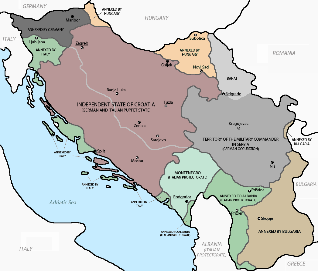
File:Axis occupation of Yugoslavia 1941-43.png
Size of this preview: 702 × 599 pixels. Other resolutions: 281 × 240 pixels | 562 × 480 pixels | 703 × 600 pixels | 900 × 768 pixels | 1,047 × 894 pixels.
Original file (1,047 × 894 pixels, file size: 50 KB, MIME type: image/png)
| This is a file from the Wikimedia Commons. The description on its description page there is shown below.
|

|
File:Map of the Axis occupation of Yugoslavia.svg is a vector version of this file. It should be used in place of this PNG file when not inferior.
File:Axis occupation of Yugoslavia 1941-43.png → File:Map of the Axis occupation of Yugoslavia.svg (by User:Amitchell125)
For more information, see Help:SVG. |
 |
Summary
| Description |
English: Axis occupation and partition of Yugoslavia in World War II.
Srpskohrvatski / српскохрватски: Osovinska okupacija i podijela Jugoslavije u Drugom svijetskom ratu.
Українська: Окупація та поділ Югославії країнами Осі під час Другої світової війни. |
| Date | |
| Source |
Own work using:
|
| Author | DIREKTOR (derived from PANONIAN's work) |
| Other versions |
    |
Licensing
self-made map by user:DIREKTOR
| I, the copyright holder of this work, release this work into the public domain. This applies worldwide. In some countries this may not be legally possible; if so: I grant anyone the right to use this work for any purpose, without any conditions, unless such conditions are required by law. |
References
- Istorijski atlas, Geokarta, Beograd, 1999.
- Školski istorijski atlas, Zavod za izdavanje udžbenika SR Srbije, Beograd, 1970.
- Povijesni atlas, Učila - Zagreb, Zagreb, 1971.
- Denis Šehić - Demir Šehić, Istorijski atlas sveta, Beograd, 2007.
- The Times History of Europe, Times Books, London, 2002.
- Richard Overy, The Times History of the 20th Century, Times Books, London, 2004.
- The Times Atlas svjetske povijesti, Cankarjeva založba, Ljubljana - Zagreb, 1986.
- Tim Džuda, Srbi - istorija, mit i razaranje Jugoslavije, Beograd, 2003.
- Džon R. Lempi, Jugoslavija kao istorija, Beograd, 2004.
- Fransisko Veiga, Balkanska zamka (1804-2001), Beograd, 2003.
- Dr Tomislav Bogavac, Nestajanje Srba, Niš, 1994.
- Valter Manošek, Holokaust u Srbiji, Beograd, 2007.
- http://www.terra.es/personal7/jqvaraderey/194145fc.gif Archived 2012-12-05 at Archive.today
- http://www.svetskirat.net/slike/razbijanje/zazbijanje_jugoslavije_1941.jpg
- http://www.marxists.org/subject/yugoslavia/images/maps/1941-dismemberment.jpg
- http://www.ushmm.org/lcmedia/map/lc/image/yug71020.gif
- http://www.srpska-mreza.com/MAPS/Yugoslavia/YU-Nazi-division.jpg archive copy at the Wayback Machine
- http://www.cartoko.com/content/wp-content/uploads/2010/05/Yugoslavia_1992_p038_CtryStudy.jpg[dead link]
- http://www.arhivyu.gov.rs/Data/Images/06_karta_b.jpg archive copy at the Wayback Machine
- http://terkepek.adatbank.transindex.ro/kepek/netre/211.gif
File history
Click on a date/time to view the file as it appeared at that time.
| Date/Time | Dimensions | User | Comment | |
|---|---|---|---|---|
| current | 11:20, 17 April 2017 | 1,047 × 894 (50 KB) | Jeanjung212 | Lossless Compressed/optimized png decreasing file size by 50106 bytes |
File usage
The following page uses this file: