File:Bayreuth Festspielhaus 2014-05-25.jpg

Size of this preview: 772 × 600 pixels. Other resolutions: 309 × 240 pixels | 618 × 480 pixels | 989 × 768 pixels | 1,280 × 995 pixels | 2,049 × 1,592 pixels.
Original file (2,049 × 1,592 pixels, file size: 1.88 MB, MIME type: image/jpeg)
| This is a file from the Wikimedia Commons. The description on its description page there is shown below.
|
Summary
| Description |
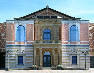
Deutsch: Das Festspielhaus in Bayreuth 2014. Die Sanierungsbedürftige Fassade ist eingerüstet, die Gerüste mit Fotodrucken der Fassade kaschiert.
English: The Festspielhaus in Bayreuth in 2014. The scaffolding around the facade is hidden under photographs of it printed on canvas.
|
||
| Date | |||
| Source | Own work | ||
| Author | El Grafo |
| Camera location | | View this and other nearby images on: OpenStreetMap |
|---|
Licensing
El Grafo, the copyright holder of this work, hereby publishes it under the following license:
This file is licensed under the Creative Commons Attribution-Share Alike 4.0 International license.
Attribution: © El Grafo / CC-BY-SA-4.0
- You are free:
- to share – to copy, distribute and transmit the work
- to remix – to adapt the work
- Under the following conditions:
- attribution – You must give appropriate credit, provide a link to the license, and indicate if changes were made. You may do so in any reasonable manner, but not in any way that suggests the licensor endorses you or your use.
- share alike – If you remix, transform, or build upon the material, you must distribute your contributions under the same or compatible license as the original.
File history
Click on a date/time to view the file as it appeared at that time.
| Date/Time | Dimensions | User | Comment | |
|---|---|---|---|---|
| current | 07:55, 26 July 2014 | 2,049 × 1,592 (1.88 MB) | El Grafo | crop, perspective, distortion |
File usage
The following page uses this file: