File:Bellvale, NY - Warwick Valley Panorama.jpg

Size of this preview: 800 × 449 pixels. Other resolutions: 320 × 180 pixels | 640 × 359 pixels | 1,273 × 715 pixels.
Original file (1,273 × 715 pixels, file size: 418 KB, MIME type: image/jpeg)
| This is a file from the Wikimedia Commons. The description on its description page there is shown below.
|
Summary
| Description |
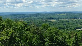
English: Panorama of the Warwick Valley, photo taken near the Bellvale Farms Creamery.
In the distance, from the south, are the Kittatinny Mountains and the High Point Monument in New Jersey, and the Shawangunk Ridge in New York. In front of these distant ridges, are the peaks Mount Adam and Mount Eve in the Black Dirt Region. |
| Date | |
| Source | Own work |
| Author | Zeete |
| Camera location | | View this and other nearby images on: OpenStreetMap |
|---|
Licensing
I, the copyright holder of this work, hereby publish it under the following license:
This file is licensed under the Creative Commons Attribution-Share Alike 4.0 International license.
- You are free:
- to share – to copy, distribute and transmit the work
- to remix – to adapt the work
- Under the following conditions:
- attribution – You must give appropriate credit, provide a link to the license, and indicate if changes were made. You may do so in any reasonable manner, but not in any way that suggests the licensor endorses you or your use.
- share alike – If you remix, transform, or build upon the material, you must distribute your contributions under the same or compatible license as the original.
| Annotations | This image is annotated: View the annotations at Commons |
File history
Click on a date/time to view the file as it appeared at that time.
| Date/Time | Dimensions | User | Comment | |
|---|---|---|---|---|
| current | 13:43, 18 February 2015 | 1,273 × 715 (418 KB) | Zeete | User created page with UploadWizard |
File usage
The following page uses this file: