File:Bilinguale Straßenbeschilderung Cottbus.jpg

Size of this preview: 800 × 600 pixels. Other resolutions: 320 × 240 pixels | 640 × 480 pixels | 1,024 × 768 pixels | 1,280 × 960 pixels | 3,052 × 2,289 pixels.
Original file (3,052 × 2,289 pixels, file size: 3.21 MB, MIME type: image/jpeg)
| This is a file from the Wikimedia Commons. The description on its description page there is shown below.
|
Summary
| DescriptionBilinguale Straßenbeschilderung Cottbus.jpg |
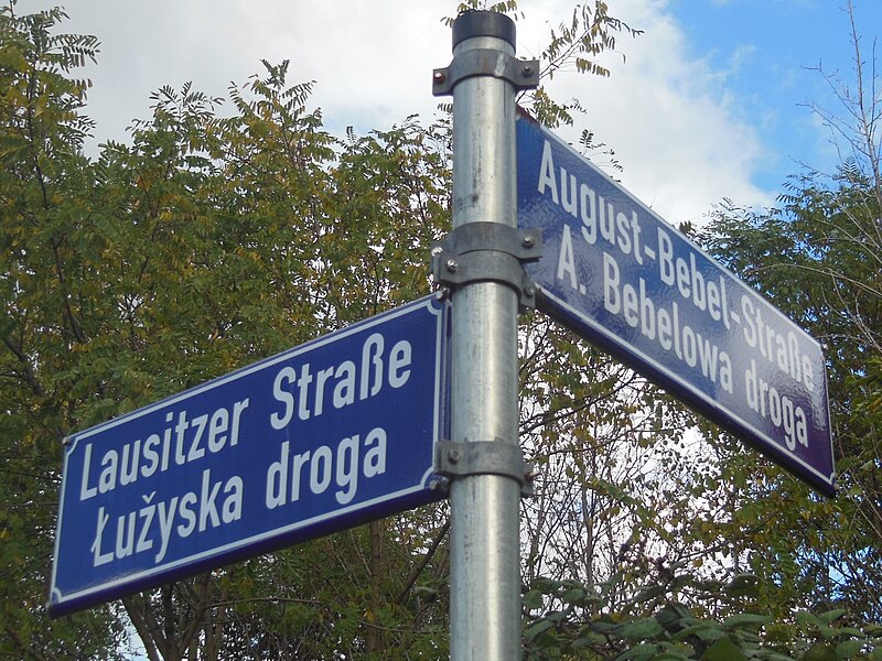
English: Bilingual, German-Lower Sorbian street sign in the city of Cottbus in Brandenburg, Germany.
Deutsch: Zweisprachiges, deutsch-niedersorbisches Straßenschild in der Stadt Cottbus in Brandenburg, Deutschland. Die vollständige Beschriftung lautet: „Lausitzer Straße, Łužyska droga, August-Bebel-Straße, A. Bebelowa droga“. |
| Date | |
| Source | Own work |
| Author | svolks |
| Other versions | File:Cottbus zweisprachige Straßenbezeichnung.jpg, File:Cottbus zweisprachige Strassenbezeichnung zugeschnitten.jpg |
| Camera location | 51° 45′ 31.37″ N, 14° 19′ 17.24″ E | View this and other nearby images on: OpenStreetMap |
|---|
Nach sieben Jahren wurde es mal Zeit für ein Update meines ersten Uploads auf die Wikipedia überhaupt(damals noch unter user:blue.dragon). Jetzt ist das Bild georeferenziert, hat ein bessere Qualität und die August-Bebel-Straße ist nun auch komplett drauf.
Licensing
I, the copyright holder of this work, hereby publish it under the following license:
This file is licensed under the Creative Commons Attribution-Share Alike 3.0 Unported license.
- You are free:
- to share – to copy, distribute and transmit the work
- to remix – to adapt the work
- Under the following conditions:
- attribution – You must give appropriate credit, provide a link to the license, and indicate if changes were made. You may do so in any reasonable manner, but not in any way that suggests the licensor endorses you or your use.
- share alike – If you remix, transform, or build upon the material, you must distribute your contributions under the same or compatible license as the original.
Captions
Add a one-line explanation of what this file represents
Items portrayed in this file
depicts
14 October 2012
51°45'31.370"N, 14°19'17.242"E
image/jpeg
aa9847b26f94b1c1a8a0e44e60c3fab2bfa4da67
3,370,941 byte
2,289 pixel
3,052 pixel
File history
Click on a date/time to view the file as it appeared at that time.
| Date/Time | Dimensions | User | Comment | |
|---|---|---|---|---|
| current | 02:50, 15 October 2012 | 3,052 × 2,289 (3.21 MB) | Svolks | Zuschnitt geändert |
File usage
The following page uses this file:
Metadata
This file contains additional information, probably added from the digital camera or scanner used to create or digitize it.
If the file has been modified from its original state, some details may not fully reflect the modified file.
| Camera manufacturer | NIKON |
|---|---|
| Camera model | COOLPIX S9300 |
| Author | Picasa |
| Exposure time | 1/400 sec (0.0025) |
| F Number | f/4.7 |
| ISO speed rating | 125 |
| Date and time of data generation | 13:50, 14 October 2012 |
| Lens focal length | 9.3 mm |
| Latitude | 51° 45′ 31.37″ N |
| Longitude | 14° 19′ 17.24″ E |
| Altitude | 185.5 meters above sea level |
| Horizontal resolution | 300 dpi |
| Vertical resolution | 300 dpi |
| Software used | COOLPIX S9300V1.1 |
| File change date and time | 11:48, 15 October 2012 |
| Y and C positioning | Co-sited |
| Exposure Program | Normal program |
| Exif version | 2.3 |
| Date and time of digitizing | 13:50, 14 October 2012 |
| Meaning of each component |
|
| Image compression mode | 4 |
| APEX exposure bias | 0 |
| Maximum land aperture | 3.6 APEX (f/3.48) |
| Metering mode | Pattern |
| Light source | Unknown |
| Flash | Flash did not fire, compulsory flash firing |
| Supported Flashpix version | 1 |
| Color space | sRGB |
| File source | Digital still camera |
| Scene type | A directly photographed image |
| Custom image processing | Normal process |
| Exposure mode | Auto exposure |
| White balance | Auto white balance |
| Digital zoom ratio | 0 |
| Focal length in 35 mm film | 52 mm |
| Scene capture type | Standard |
| Scene control | Low gain up |
| Contrast | Normal |
| Saturation | Normal |
| Sharpness | Normal |
| Subject distance range | Unknown |
| Unique image ID | 352c9f20fec20467849c043c2b3da622 |
| GPS time (atomic clock) | 11:51 |
| Satellites used for measurement | 05 |
| Reference for direction of image | Magnetic direction |
| Direction of image | 16 |
| Geodetic survey data used | WGS-84 |
| GPS date | 14 October 2012 |
| GPS tag version | 84.15.05.84 |
| IIM version | 4 |