File:Br-map1.jpg
No higher resolution available.
Br-map1.jpg (330 × 354 pixels, file size: 34 KB, MIME type: image/jpeg)
| This is a file from the Wikimedia Commons. The description on its description page there is shown below.
|
| Description |
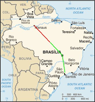
English: Map of Brazil showing the presumed flight paths of Gol Transportes Aéreos Flight 1907 and the Embraer Legacy 600 aircraft that it collided with to the crash site (source: CENIPA Final report)
|
||||||||
| Date | |||||||||
| Source | Derivative work of File:Brazil-CIA_WFB_Map.png | ||||||||
| Author | Crum375 (talk) | ||||||||
| Permission (Reusing this file) |
|

File history
Click on a date/time to view the file as it appeared at that time.
| Date/Time | Dimensions | User | Comment | |
|---|---|---|---|---|
| current | 09:21, 6 October 2006 | 330 × 354 (34 KB) | Xamã~commonswiki | Original was Br-map.gif from WikiCommmons, placed crash coords 10.29S 53.15W, drew lines between Sao Paulo, Manaus and Brasilia, to crash coord location, per GoogleMaps as reference |
File usage
The following page uses this file: