File:Bristol Temple Meads Station and an Up LMR express 2093479 27e4170c.jpg

Size of this preview: 800 × 467 pixels. Other resolutions: 320 × 187 pixels | 640 × 374 pixels | 1,024 × 598 pixels.
Original file (1,024 × 598 pixels, file size: 103 KB, MIME type: image/jpeg)
| This is a file from the Wikimedia Commons. The description on its description page there is shown below.
|
Summary
| Description |
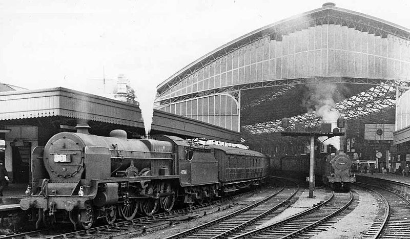
English: Bristol Temple Meads Station and an Up LMR express. Via westward, from the north/east end of No. 9 platform. The 08.50 Paignton to Leeds express stands at No. 7 platform with LMS Fowler Class 6P 4-6-0 No. 45506 'The Royal Pioneer Corps', which has just taken over for the journey up the ex-Midland main line via Birmingham (New St.). In the centre road is an ex-LMS 4F 0-6-0 No. 44560. |
| Date | |
| Source | From geograph.org.uk |
| Author | Ben Brooksbank |
| Permission (Reusing this file) |
Creative Commons Attribution Share-alike license 2.0 |
| Attribution (required by the license) | Ben Brooksbank / Bristol Temple Meads Station and an Up LMR express / |
| Camera location | | View this and other nearby images on: OpenStreetMap |
|---|
Licensing

|
This image was taken from the Geograph project collection. See this photograph's page on the Geograph website for the photographer's contact details. The copyright on this image is owned by Ben Brooksbank and is licensed for reuse under the Creative Commons Attribution-ShareAlike 2.0 license.
|
This file is licensed under the Creative Commons Attribution-Share Alike 2.0 Generic license.
Attribution: Ben Brooksbank
- You are free:
- to share – to copy, distribute and transmit the work
- to remix – to adapt the work
- Under the following conditions:
- attribution – You must give appropriate credit, provide a link to the license, and indicate if changes were made. You may do so in any reasonable manner, but not in any way that suggests the licensor endorses you or your use.
- share alike – If you remix, transform, or build upon the material, you must distribute your contributions under the same or compatible license as the original.
File history
Click on a date/time to view the file as it appeared at that time.
| Date/Time | Dimensions | User | Comment | |
|---|---|---|---|---|
| current | 02:47, 29 October 2010 | 1,024 × 598 (103 KB) | Chevin | larger version |
File usage
The following page uses this file: