File:COMITATUS HOLLANDIAE 1682.jpg

Size of this preview: 722 × 599 pixels. Other resolutions: 289 × 240 pixels | 578 × 480 pixels | 723 × 600 pixels | 925 × 768 pixels | 1,233 × 1,024 pixels | 4,400 × 3,653 pixels.
Original file (4,400 × 3,653 pixels, file size: 4.19 MB, MIME type: image/jpeg)
| This is a file from the Wikimedia Commons. The description on its description page there is shown below.
|
Summary
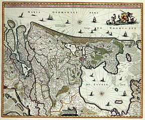
| Description | COMITATUS HOLLANDIAE TABULA PLURIBUS LOCIS RECENS EMENDATA A NICOLAO VISSCHER (historic map of Holland) |
| Date | |
| Source | www.geheugenvannederland.nl |
| Author | Nicolaas Visscher |
Licensing
|
This work is in the public domain in its country of origin and other countries and areas where the copyright term is the author's life plus 100 years or fewer. | |
| This file has been identified as being free of known restrictions under copyright law, including all related and neighboring rights. | |
File history
Click on a date/time to view the file as it appeared at that time.
| Date/Time | Dimensions | User | Comment | |
|---|---|---|---|---|
| current | 08:46, 4 January 2008 | 4,400 × 3,653 (4.19 MB) | P199 | {{Information |Description=''COMITATUS HOLLANDIAE TABULA PLURIBUS LOCIS RECENS EMENDATA A NICOLAO VISSCHER'' (historic map of Holland) |Source=www.geheugenvannederland.nl |Date=1682 |Author=Nicolaas Visscher |Permission= |other_versions= }} [[Category:Ol |
File usage
The following page uses this file: