File:COVID-19 Outbreak Cases in New Zealand (DHB Totals).svg

Size of this PNG preview of this SVG file: 460 × 599 pixels. Other resolutions: 184 × 240 pixels | 369 × 480 pixels | 461 × 600 pixels | 590 × 768 pixels | 787 × 1,024 pixels | 650 × 846 pixels.
Original file (SVG file, nominally 650 × 846 pixels, file size: 138 KB)
| This is a file from the Wikimedia Commons. The description on its description page there is shown below.
|
.svg)
Summary

|
This file may be updated to reflect new information. If you wish to use a specific version of the file without new updates being mirrored, please upload the required version as a separate file. |
| Description |
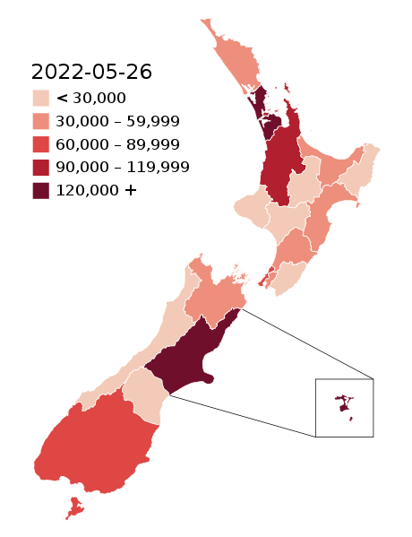
English: Map of the COVID-19 outbreak in New Zealand with case totals by District Health Board (DHB) as of 28 February 2022. Be aware that since this is a rapidly evolving situation, new cases may not be immediately represented visually. Refer to the primary article 2019–20 coronavirus outbreak by country and territory or the World Health Organization's situation reports for most recent reported case information.
The data ranges for each colour may be updated periodically to reflect changing data. Numerical ranges for each colour are calculated to give equally sized ranges. N.B: Stewart Island and Chatham Island are associated with the Southern DHB and Canterbury DHB (respectively). The colours for those islands represent the overall DHB case numbers, not the number of cases present on those islands specifically. |
| Date | |
| Source |
|
| Author |
Base map: Base map: Stats NZ, edits by Air55 Colourisation: multiple authors |
.svg)
Licensing
This file is licensed under the Creative Commons Attribution-Share Alike 4.0 International license.
- You are free:
- to share – to copy, distribute and transmit the work
- to remix – to adapt the work
- Under the following conditions:
- attribution – You must give appropriate credit, provide a link to the license, and indicate if changes were made. You may do so in any reasonable manner, but not in any way that suggests the licensor endorses you or your use.
- share alike – If you remix, transform, or build upon the material, you must distribute your contributions under the same or compatible license as the original.
File history
Click on a date/time to view the file as it appeared at that time.
| Date/Time | Dimensions | User | Comment | |
|---|---|---|---|---|
| current | 20:55, 25 May 2022 | 650 × 846 (138 KB) | Air55 | Updated totals as of 26 May 2022 |
File usage
The following 2 pages use this file:
.svg)