File:Canning Town station geograph-3099691-by-Ben-Brooksbank.jpg

Size of this preview: 800 × 485 pixels. Other resolutions: 320 × 194 pixels | 640 × 388 pixels | 1,024 × 621 pixels | 1,280 × 776 pixels | 2,389 × 1,449 pixels.
Original file (2,389 × 1,449 pixels, file size: 2.97 MB, MIME type: image/jpeg)
| This is a file from the Wikimedia Commons. The description on its description page there is shown below.
|
Summary
| Description |
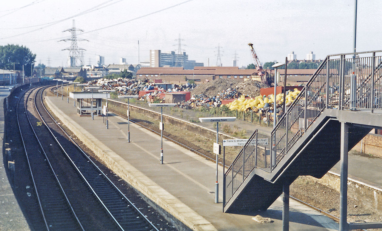
English: Canning Town station, 1983. View NW, towards Stratford on the ex-GE North Woolwich branch. By this time there was little goods traffic to the Docks remaining, but the passenger service still ran on the original line to North Woolwich and continued until 9/12/06. On 6/3/94 the Docklands Light Railway opened a new station nearby and this station was closed 6/6/96 - 5/3/98, and on 14/5/99 the Underground (Jubilee Line Extension) station was opened here. (See also TQ4080 : Up platform of Custom House (Victoria Dock) station, 1983). |
| Date | Taken on 29 August 1983 |
| Source | From geograph.org.uk |
| Author | Ben Brooksbank |
| Permission (Reusing this file) |
Creative Commons Attribution Share-alike license 2.0 |
| Attribution (required by the license) | Ben Brooksbank / Canning Town station, 1983 / |
| Camera location | | View this and other nearby images on: OpenStreetMap |
|---|
Licensing

|
This image was taken from the Geograph project collection. See this photograph's page on the Geograph website for the photographer's contact details. The copyright on this image is owned by Ben Brooksbank and is licensed for reuse under the Creative Commons Attribution-ShareAlike 2.0 license.
|
This file is licensed under the Creative Commons Attribution-Share Alike 2.0 Generic license.
Attribution: Ben Brooksbank
- You are free:
- to share – to copy, distribute and transmit the work
- to remix – to adapt the work
- Under the following conditions:
- attribution – You must give appropriate credit, provide a link to the license, and indicate if changes were made. You may do so in any reasonable manner, but not in any way that suggests the licensor endorses you or your use.
- share alike – If you remix, transform, or build upon the material, you must distribute your contributions under the same or compatible license as the original.
File history
Click on a date/time to view the file as it appeared at that time.
| Date/Time | Dimensions | User | Comment | |
|---|---|---|---|---|
| current | 10:45, 1 September 2012 | 2,389 × 1,449 (2.97 MB) | Chevin | == {{int:filedesc}} == {{Information |Description={{en|1='''Canning Town station, 1983.'''<br/> View NW, towards Stratford on the ex-GE North Woolwich branch. By this time there was little goods traffic to the Docks remaining, but the passenger service... |
File usage
The following page uses this file: