File:Cape Verde-CIA WFB Map.png
No higher resolution available.
Cape_Verde-CIA_WFB_Map.png (330 × 355 pixels, file size: 8 KB, MIME type: image/png)
| This is a file from the Wikimedia Commons. The description on its description page there is shown below.
|
| Description |
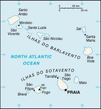
English: A map of the Republic of Cabo Verde, showing major cities. |
|||
| Date | published 2004 | |||
| Source | CIA, The World Factbook, 2004. | |||
| Author | CIA | |||
| Permission (Reusing this file) |
|

File history
Click on a date/time to view the file as it appeared at that time.
| Date/Time | Dimensions | User | Comment | |
|---|---|---|---|---|
| current | 02:12, 27 March 2005 | 330 × 355 (8 KB) | Wolfman~commonswiki | {{CIA-map}} |
File usage
The following page uses this file: