| DescriptionCarte TGV.svg |
Français : La carte du réseau voyageurs de la SNCF, les TGV internationaux inclus
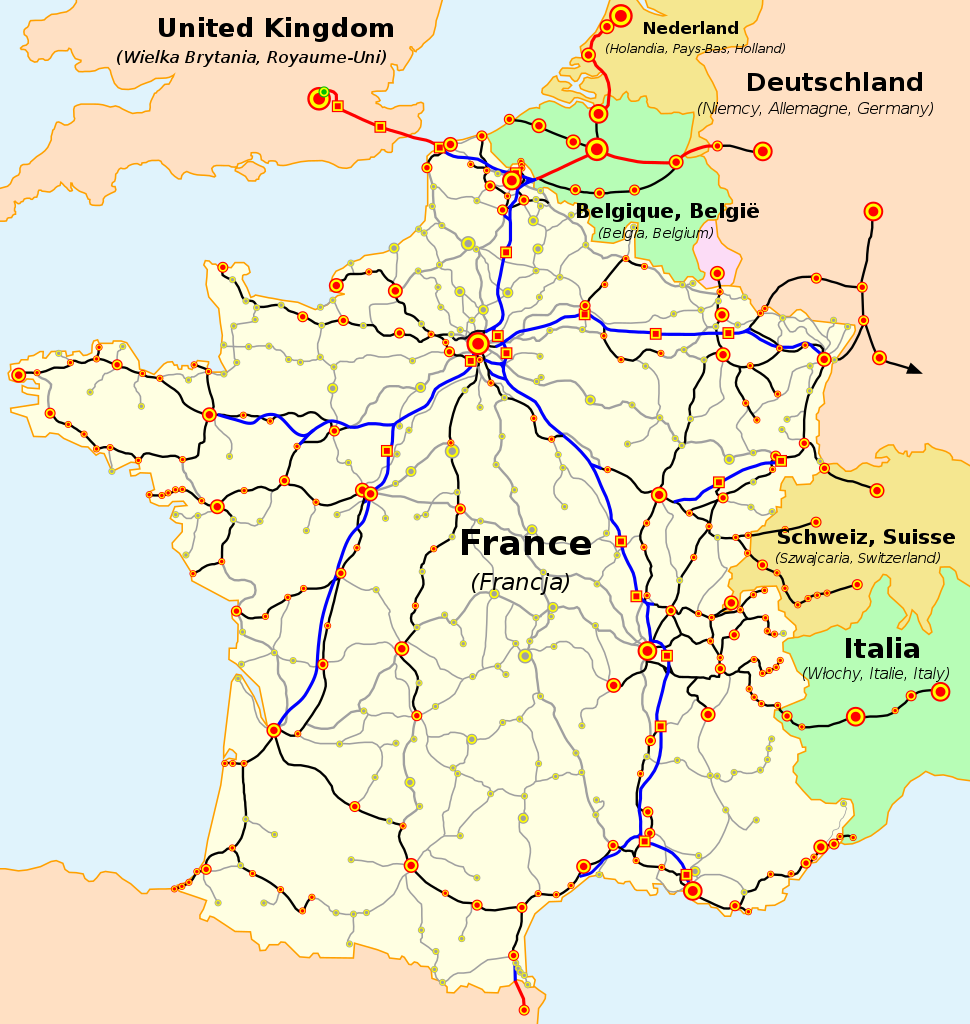
English: The map of French railways (SNCF) passengers service, including international TGV high-speed trains
Deutsch: Karte der französischen Eisenbahn (SNCF) mit TGV Hochgeschwindigkeitsnetz
Español: Mapa de las líneas de ferrocarril de la SNCF, incluidas las líneas de TGV (alta velocidad)
Čeština: Mapa tratí francouzských železnic (SNCF) s přepravou cestujících včetně mezinárodních spojení TGV
Nederlands: Kaart van de Franse Spoorwegen (SNCF), inclusief internationale TGV hogesnelheidstreinen
Polski: Mapa sieci połączeń pasażerskich kolei francuskich (SNCF), uwzlędniająca międzynarodowe połączenia pociągami TGV
Русский: Карта пассажирского железнодорожного транспорта Франции, включая международные скоростные поезда TGV
Slovenčina: Mapa tratí francúzskych železníc (SNCF) s prepravou cestujúcich a medzinárodných spojení TGV
Català: La xarxa TGV: -en blau i en vermell: línies d'alta velocitat, -en negre: línies clàssiques per on circulen trens TGV, -puntejat: línies en projecte (TGV Est)
(cs) Vysvětlivky
- Železniční tratě:
- modrá — vysokorychlostní tratě (LGV) ve Francii
- červená — vysokorychlostní tratě mimo Francii
- černá — běžné tratě s provozem TGV
- čárkovaná červená/modrá — vysokorychlostní tratě ve stavbě
- čárkovaná černá — běžné tratě s plánovaným provozem TGV v blízké budoucnosti
- šedá — ostatní tratě s dopravou cestujících
- Železniční stanice a města:
- červená:
- kruhy — stanice obsluhovaná TGV
- čtverce — stanice obsluhovaná výhradně TGV (na LGV)
- zelená:
- kruhy — stanice s plánovanou obsluhou TGV v blízké budoucnosti
- čtverce — stanice na LGV ve stavbě
- šedá — stanice s dopravou cestujících běžnými vlaky
Velikost značek označuje přibližně velikost měst
(de) Legende
- Eisenbahnlinien:
- blau - Hochgeschwindigkeitsstrecken in Frankreich,
- rot - Hochgeschwindigkeitsstrecken außerhalb Frankreichs,
- schwarz - Klassische Bahnlinien mit TGV-Nutzung,
- rot und blau gepunktet - Hochgeschwindigkeitsstrecken in Bau,
- schwarz gepunktet - Klassische Bahnlinien mit TGV-Nutzung in Planung,
- grau - andere klassische Bahnlinien im Passagierverkehr
- Bahnhöfe und Städte:
- rot:
- Punkte - mit TGV-Anbindung,
- Quadrate - ausschließlich TGV-Anbindung
- grün:
- Punkte - mit zukünftiger TGV-Anbindung,
- Quadrate - mit zukünftiger, ausschließlicher TGV-Anbindung,
- Graue Punkte - andere Personenbahnhöfe,
- Die Größe der Punkte spiegelt die Größe der Städte wieder.
(es) Leyenda
- Lineas Ferroviarias:
- Azul- Lineas de alta velocidad (LGV) en Francia.
- Rojo- Lineas de alta velocidad exteriores a Francia.
- Negro- Lineas ferroviarias "clasicas" con servicio TGV.
- Azul y Rojo punteados- Lineas de alta velocidad en construcción.
- Negro punteado- Lineas "clasicas" con servicio TGV planeadas para un futuro cercano.
- Gris- Otras lineas ferroviarias "clasicas" con servicio de pasajeros.
- Estaciones Ferroviarias o Ciudades:
- Rojo:
- Puntos- Con servicio TGV
- Cuadrados- Con servicio TGV solamente (Estaciones en LGV)
- Verde:
- Puntos- Con servicio TGV en un futuro cercano.
- Cuadrados- Con servicio TGV solamente (Estaciones en LGV). En construcción.
- Puntos Grises- Con otros servicios de pasajeros; los tamaños del punto indican los tamaños de la ciudad (arbitrarios).
(en) Legend
- Railway lines:
- blue - high-speed (LGV) lines in France,
- red - high-speed lines outside France,
- black - 'classic' railway lines with TGV service,
- dashed red and blue - high-speed lines in construction,
- dashed black - 'classic' lines with TGV service planned in near future,
- grey - other 'classic' railway lines with passenger service.
- Railway stations or cities:
- red:
- dots - with TGV service,
- squares - with TGV service only (stations on LGV)
- green:
- dots - with TGV service in near future,
- squares with TGV service only (stations on LGV) in construction,
- grey dots - with other passenger service,
- dot sizes indicate town sizes (arbitrary).
(fr) Légende
- Lignes ferroviaires:
- bleus - lignes à grande vitesse (LGV) en France,
- rouges - lignes à grande vitesse au dehors de la France,
- noires - lignes 'classiques' avec le service TGV,
- rouges et bleues entrecoupées - lignes à grande vitesse en construction,
- noires entrecoupées - lignes 'classiques' dont le service TGV est prévu,
- grises - autres lignes 'classiques' du réseau voyageurs.
- Gares ferroviaires ou villes:
- rouges:
- points - avec le service TGV,
- carreaux - avec le service TGV uniquement (gares sur les lignes nouvelles)
- verts:
- points - dont le service TGV est prévu,
- carreaux - pour les TGV uniquement (gares sur les lignes nouvelles, en construction),
- points gris - les autres stations ou villes du réseau voyageurs.
- les tailles des points indiquent les grandeurs des villes (subjective)
(nl) Legenda
- Spoorwegen:
- blauw - hogesnelheidslijnen (LGV) in Frankrijk
- rood - hogesnelheidslijnen buiten Frankrijk
- zwart - oude lijnen met hogesnelheidstreinen
- rood-blauwe stippellijn - hogesnelheidslijn in opbouw
- zwarte stippellijn - oude lijnen waarop hogesnelheidstreinen gepland worden
- grijs: andere oude lijnen voor personenvervoer
- Stations en steden:
- rood:
- bollen - bediend door de HST
- vierkanten - enkel bediend door de HST (stations langs nieuwe lijnen)
- groen:
- bollen - plaats waar bediening door de HST wordt gepland
- vierkanten - enkel bediening door de HST wordt voorzien
- grijze bollen - andere stations en steden voor personenvervoer
- de grootte van de bollen geven de grootte van de steden weer (subjectief)
(pl) Legenda
- Linie kolejowe:
- niebieskie - linie wysokich prędkości (LGV) we Francji,
- czerwone - linie wysokich prędkości poza Francją,
- czarne - linie "klasyczne", po których kursują pociągi TGV,
- czerwone i niebieskie przerywane - linie wysokich prędkości w budowie,
- czarne przerywane - linie 'klasyczne' po który pociągi TGV będą kursować w niedalekiej przyszłości,
- szare - pozostałe linie "klasyczne", po których kursują pociągi pasażerskie.
- Dworce kolejowe lub miasta:
- czerwone:
- punkty - na których zatrzymują się pociągi TGV,
- kwadraty - na których zatrzymują się wyłącznie pociągi TGV (dworce na liniach wysokich prędkości),
- zielone:
- punkty - do których pociągi TGV dotrą w niedalekiej przyszłości,
- kwadraty - dworce w budowie, przeznaczone wyłącznie dla pociągów TGV,
- szare punkty - pozostałe dworce kolejowe na liniach "klasycznych".
- wielkość punktów wskazuje wielkość stacji lub miasta (subiektywnie).
(sk) Vysvetlivky
- Železničné trate:
- modrá - vysokorýchlostné trate (LGV) vo Francúzsku,
- červená - vysokorýchlostné trate mimo Francúzska,
- čierna - štandardné trate s prevádzkou TGV,
- prerušovaná červeno-modrá - vysokorýchlostné trate vo výstavbe,
- prerušovaná čierna - štandardné trate s prevádzkou TGV plánovanou v blízkej budúcnosti,
- šedá - ďalšie štandardné trate s prepravou cestujúcich.
- Železničné stanice alebo mestá:
- červená:
- body - s prevádzkou TGV ,
- štvorce - len s prevádzkou TGV (stanice na LGV)
- zelené:
- body - s prevádzkou TGV plánovanou v blízkej budúcnosti,
- štvorce - len s prevádzkou TGV (stanice na LGV) vo výstavbe,
- šedé body - s ostatnou prepravou cestujúcich
Veľkosť bodov znamená veľkosť miest (orientačne). |

