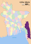
File:Chittagong Hill Tracts.PNG
Chittagong_Hill_Tracts.PNG (428 × 599 pixels, file size: 74 KB, MIME type: image/png)
File history
Click on a date/time to view the file as it appeared at that time.
| Date/Time | Dimensions | User | Comment | |
|---|---|---|---|---|
| current | 08:12, 23 March 2010 | 428 × 599 (74 KB) | AnonyLog | == {{int:filedesc}} == {{Information |Description= CHTs locator map in purple in Bangladesh |Source=Self-made based on File:BD Districts LOC.svg |Date= 2009-09-06 |Author= Armanaziz adapted by User:AnonyLog |other_versions= }} |
File usage
The following page uses this file:


