File:Circuit Mont-Tremblant Track Map.svg

Size of this PNG preview of this SVG file: 420 × 599 pixels. Other resolutions: 168 × 240 pixels | 336 × 480 pixels | 420 × 600 pixels | 538 × 768 pixels | 717 × 1,024 pixels | 597 × 852 pixels.
Original file (SVG file, nominally 597 × 852 pixels, file size: 78 KB)
| This is a file from the Wikimedia Commons. The description on its description page there is shown below.
|
Summary
| Description |
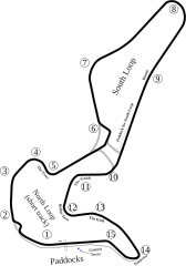
English: Track map for Circuit Mont-Tremblant. Created with Inkscape. |
| Date | |
| Source | Own work |
| Author | Will Pittenger |
| Other versions |
 |
| Camera location | | View this and other nearby images on: OpenStreetMap |
|---|
Licensing
| I, the copyright holder of this work, release this work into the public domain. This applies worldwide. In some countries this may not be legally possible; if so: I grant anyone the right to use this work for any purpose, without any conditions, unless such conditions are required by law. |
File history
Click on a date/time to view the file as it appeared at that time.
| Date/Time | Dimensions | User | Comment | |
|---|---|---|---|---|
| current | 23:49, 6 June 2008 | 597 × 852 (78 KB) | Will Pittenger | Added missing Turn 5 |
File usage
The following page uses this file: