File:Comanche 1718.jpg

Size of this preview: 639 × 599 pixels. Other resolutions: 256 × 240 pixels | 512 × 480 pixels | 640 × 600 pixels | 931 × 873 pixels.
Original file (931 × 873 pixels, file size: 868 KB, MIME type: image/jpeg)
| This is a file from the Wikimedia Commons. The description on its description page there is shown below.
|
Summary
| Description |
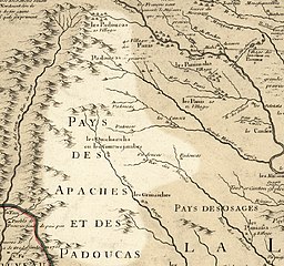
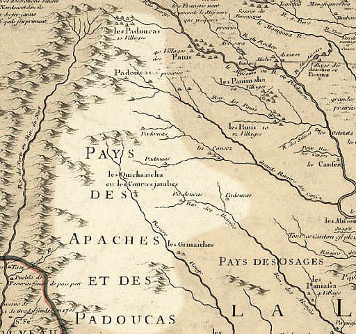
English: Comanche (Padoucas) territory, 1718, approximate area highlighted, from Carte de la Louisiane et du cours du Mississipi by Guillaume de L'Isle. My contributions cleaning and highlighting are also donated to Public Domain. Bill Whittaker 17:48, 15 December 2009 (UTC) |
| Date | (mod. 2009) |
| Source | Library of Congress Public Domain Site: http://hdl.loc.gov/loc.gmd/g3700.ct000666 |
| Author | Guillaume de L'Isle |
| Permission (Reusing this file) |
US Govt Public Domain, also author +100 years |
Licensing
This work is in the public domain in the United States because it is a work prepared by an officer or employee of the United States Government as part of that person’s official duties under the terms of Title 17, Chapter 1, Section 105 of the US Code.
Note: This only applies to original works of the Federal Government and not to the work of any individual U.S. state, territory, commonwealth, county, municipality, or any other subdivision. This template also does not apply to postage stamp designs published by the United States Postal Service since 1978. (See § 313.6(C)(1) of Compendium of U.S. Copyright Office Practices). It also does not apply to certain US coins; see The US Mint Terms of Use.
|
 | |
| This file has been identified as being free of known restrictions under copyright law, including all related and neighboring rights. | ||
|
This work is in the public domain in its country of origin and other countries and areas where the copyright term is the author's life plus 100 years or fewer. | |
| This file has been identified as being free of known restrictions under copyright law, including all related and neighboring rights. | |
Original upload log
The original description page was here. All following user names refer to en.wikipedia.
| Date/Time | Dimensions | User | Comment |
|---|---|---|---|
| 2009-12-15 17:48 | 931×873× (888550 bytes) | Billwhittaker | == Summary == {{Information |Description = [[Comanche]] (Padoucas) territory, 1718, approximate area highlighted, from ''Carte de la Louisiane et du cours du Mississipi'' by [[Guillaume de L'Isle]]. |Source = Library of Congress Public Domain |
File history
Click on a date/time to view the file as it appeared at that time.
| Date/Time | Dimensions | User | Comment | |
|---|---|---|---|---|
| current | 12:13, 13 May 2015 | 931 × 873 (868 KB) | Rcbutcher | Transferred from en.wikipedia |
File usage
The following page uses this file: