File:Dürnstein - ehem. Augustinerchorherren-Stift, Turm (b).JPG

Size of this preview: 400 × 600 pixels. Other resolutions: 160 × 240 pixels | 320 × 480 pixels | 512 × 768 pixels | 683 × 1,024 pixels | 1,934 × 2,900 pixels.
Original file (1,934 × 2,900 pixels, file size: 4.43 MB, MIME type: image/jpeg)
| This is a file from the Wikimedia Commons. The description on its description page there is shown below.
|
Summary
| Description |
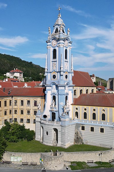
Deutsch: Das Wahrzeichen der niederösterreichischen Stadtgemeinde Dürnstein und teilweise auch das der Wachau, der Glocken- bzw. Kirchturm des ehem. Augustinerchorherren-Stiftes.
Im Zuge der Barockisierung der Klosteranlage zwischen 1715 und 1733 erhielt auch der Turm, der einen markanten Akzent in der Landschaft setzt, sein heutiges Erscheinungsbild. Errichtet wurde der rd. 40 Meter hohe Turm von Joseph Munggenast - zum Teil nach Plänen von Jakob Prandtauer und Matthias Steinl. In den 1980er Jahren wurde das ehem. Kloster um rd. 50 Mio. Schilling renoviert und saniert. Dabei erhielt der Turm seine ursprüngliche Farbgebung wieder (weiß und smalteblau). Dies führte in der Öffentlichkeit und in den Medien zu sehr kontroversen Diskussionen: [1]. English: Bell tower of the former monastery in Dürnstein, Lower Austria. |
| Date | |
| Source | Own work |
| Author | C.Stadler/Bwag |
| Permission (Reusing this file) |
Deutsch: Hallo, du darfst mein Foto kostenlos nutzen, aber nenne mich bitte als Fotograf, beispielsweise „Foto: C.Stadler/Bwag“ oder © C.Stadler/Bwag; CC-BY-SA-4.0. Auf mehr Angaben bestehe ich nicht - im Gegensatz zu manch anderen, die die Vorgaben der unten angeführten Lizenzierung auf Punkt und Beistrich einfordern. English: Feel free to use my photos, but please mention me as the author like © C.Stadler/Bwag or © C.Stadler/Bwag; CC-BY-SA-4.0 (that's good enough) and if you want send me a message: bwag@gmx.net. |
| Other versions |
|

.JPG)
| Object location | | View this and other nearby images on: OpenStreetMap |
|---|
.JPG¶ms=048.395320_N_0015.519230_E_globe:Earth_class:object_type:object__&language=en)
| Camera location | | View this and other nearby images on: OpenStreetMap |
|---|
.JPG¶ms=048.395140_N_0015.518010_E_globe:Earth_type:camera_heading:90.00&language=en)
Licensing
I, the copyright holder of this work, hereby publish it under the following license:
This file is licensed under the Creative Commons Attribution-Share Alike 4.0 International license.
- You are free:
- to share – to copy, distribute and transmit the work
- to remix – to adapt the work
- Under the following conditions:
- attribution – You must give appropriate credit, provide a link to the license, and indicate if changes were made. You may do so in any reasonable manner, but not in any way that suggests the licensor endorses you or your use.
- share alike – If you remix, transform, or build upon the material, you must distribute your contributions under the same or compatible license as the original.
File history
Click on a date/time to view the file as it appeared at that time.
| Date/Time | Dimensions | User | Comment | |
|---|---|---|---|---|
| current | 13:33, 2 January 2022 | 1,934 × 2,900 (4.43 MB) | Bwag | == {{int:filedesc}} == {{Information |Description= {{de|1= Das Wahrzeichen der niederösterreichischen Stadtgemeinde Dürnstein und teilweise auch das der Wachau, der Glocken- bzw. Kirchturm des ehem. Augustinerchorherren-Stiftes.<br/>Im Zuge der Barockisierung der Klosteranlage zwischen 1715 und 1733 erhielt auch der Turm, der einen markanten Akzent in der Landschaft setzt, sein heutiges Erscheinungsbild. Errichtet wurde der rd. 40 Meter hohe Turm von Joseph Munggenast - zum Teil nach Plänen... |
File usage
The following page uses this file:
.JPG)