File:Dalriada.jpg
No higher resolution available.
Dalriada.jpg (509 × 531 pixels, file size: 34 KB, MIME type: image/jpeg)
| This is a file from the Wikimedia Commons. The description on its description page there is shown below.
|
Summary
| Description |
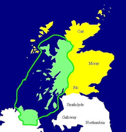
English: Extent of the Kingdom of Dál Riata (in green), c. AD 590. Yellow areas show occupation by the Picts.
Español: Mapa de Dalriada hacia el año 590. Las regiones pictas están marcadas en amarillo. |
| Source | Copied from en:Image:Dalriada.jpg. |
| Author | en:User:Briangotts |


|
This historical map image could be re-created using vector graphics as an SVG file. This has several advantages; see Commons:Media for cleanup for more information. If an SVG form of this image is available, please upload it and afterwards replace this template with
{{vector version available|new image name}}.
It is recommended to name the SVG file “Dalriada.svg”—then the template Vector version available (or Vva) does not need the new image name parameter. |
Licensing
| This work has been released into the public domain by its author, Briangotts. This applies worldwide. In some countries this may not be legally possible; if so: |
File history
Click on a date/time to view the file as it appeared at that time.
| Date/Time | Dimensions | User | Comment | |
|---|---|---|---|---|
| current | 08:49, 27 September 2005 | 509 × 531 (34 KB) | R | Copied from en:Image:Dalriada.jpg. Author: en:User:Briangotts. Extent of the Kingdom of Dalriada (in green), c.590 CE. Yellow areas show occupation by the Picts. {{PD}} |
File usage
The following page uses this file: