File:Decolonization - World In 1945 en.svg

Original file (SVG file, nominally 1,421 × 816 pixels, file size: 802 KB)
| This is a file from the Wikimedia Commons. The description on its description page there is shown below.
|
Summary
| Description |
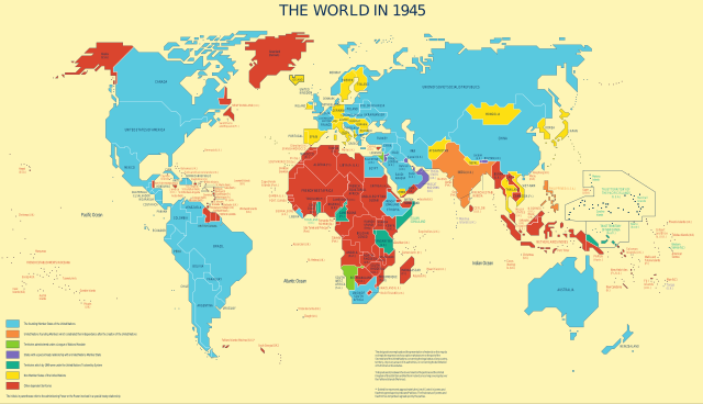
English: Map was used to show the progress of the UN's decolonization efforts.
Derivative work based on UN Map No. 4135 Rev. 3, updated in May 2010 by UN Department of Field Support, Cartographic Section Taken from the UN's decolonization website. Only modification was a conversion to SVG and per UN license, removal of reference information from the map. In fulfillment of a Wikipedia Graphics Lab: Map Workshop request by User:Gryffindor, referencing a photo taken by User:Deror_avi at the UN building.English: The founding Member States of the UN English: UN founding Members which celebrated their independence after the creation of the UN English: Territories administered under a League of Nations Mandate English: States with a special treaty relationship with a UN Member State English: Territories which by 1949 were under the UN Trusteeship System English: Non-Member States of the UN English: Other dependent territories |
|||
| Date | Unknown date, last update in May 2010 | |||
| Source | The United Nations and Decolonization | |||
| Author | United Nations Department of Field Support, Cartographic Section | |||
| Permission (Reusing this file) |
|

File history
Click on a date/time to view the file as it appeared at that time.
| Date/Time | Dimensions | User | Comment | |
|---|---|---|---|---|
| current | 18:31, 8 July 2022 | 1,421 × 816 (802 KB) | Kwamikagami | Reverted to version as of 22:10, 21 May 2012 (UTC) |
File usage
The following 2 pages use this file: