File:Edziza042909-- 066-15.jpg
Size of this preview: 800 × 449 pixels. Other resolutions: 320 × 180 pixels | 640 × 359 pixels | 1,024 × 575 pixels | 1,800 × 1,011 pixels.
Original file (1,800 × 1,011 pixels, file size: 1.02 MB, MIME type: image/jpeg)
| This is a file from the Wikimedia Commons. The description on its description page there is shown below.
|
Summary
| DescriptionEdziza042909-- 066-15.jpg |
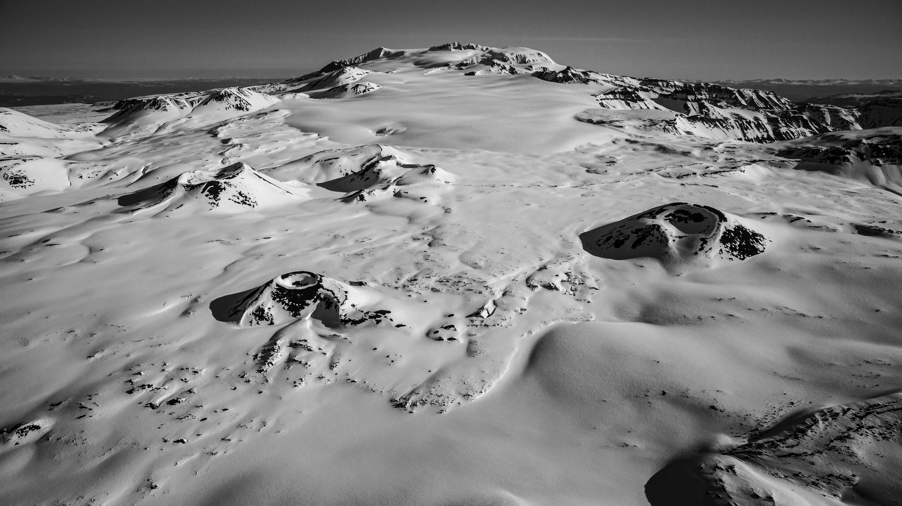
English: Mount Edziza from the south. Coffee Crater is at left center, Techno Glacier is at center and Ice Peak (the remains of another ancient volcano in the Mount Edziza Volcanic Complex) at upper right center. Edziza itself is at upper center, the southern rim of its caldera silhouetted against the sky. The image comes from an aerial photographic flight conducted on April 29, 2009, originating from Dease Lake, British Columbia. |
| Date | |
| Source | Own work |
| Author | Jagged Ridge Imaging |
| Camera location | 57° 36′ 27.31″ N, 130° 39′ 45.17″ W | View this and other nearby images on: OpenStreetMap |
|---|
Licensing
I, the copyright holder of this work, hereby publish it under the following license:
This file is licensed under the Creative Commons Attribution-Share Alike 4.0 International license.
- You are free:
- to share – to copy, distribute and transmit the work
- to remix – to adapt the work
- Under the following conditions:
- attribution – You must give appropriate credit, provide a link to the license, and indicate if changes were made. You may do so in any reasonable manner, but not in any way that suggests the licensor endorses you or your use.
- share alike – If you remix, transform, or build upon the material, you must distribute your contributions under the same or compatible license as the original.
Captions
Mount Edziza
Items portrayed in this file
depicts
some value
29 April 2009
0.00015625 second
28 millimetre
400
image/jpeg
File history
Click on a date/time to view the file as it appeared at that time.
| Date/Time | Dimensions | User | Comment | |
|---|---|---|---|---|
| current | 04:06, 11 June 2022 | 1,800 × 1,011 (1.02 MB) | John Scurlock | Reverted to version as of 14:59, 7 June 2022 (UTC) |
File usage
The following page uses this file:
Metadata
This file contains additional information, probably added from the digital camera or scanner used to create or digitize it.
If the file has been modified from its original state, some details may not fully reflect the modified file.
| Camera manufacturer | Canon |
|---|---|
| Camera model | Canon EOS 5D Mark II |
| Author | Photographer: John Scurlock, Photographer & Pilot |
| Copyright holder |
|
| Exposure time | 1/6,400 sec (0.00015625) |
| F Number | f/8 |
| ISO speed rating | 400 |
| Date and time of data generation | 08:33, 29 April 2009 |
| Lens focal length | 28 mm |
| Latitude | 57° 36′ 27.31″ N |
| Longitude | 130° 39′ 45.16″ W |
| Altitude | 2,295 meters above sea level |
| Horizontal resolution | 300 dpi |
| Vertical resolution | 300 dpi |
| Software used | Adobe Photoshop Lightroom Classic 11.3.1 (Windows) |
| File change date and time | 07:44, 7 June 2022 |
| Exposure Program | Aperture priority |
| Exif version | 2.31 |
| Date and time of digitizing | 08:33, 29 April 2009 |
| APEX shutter speed | 12.643856 |
| APEX aperture | 6 |
| APEX exposure bias | -1 |
| Maximum land aperture | 4 APEX (f/4) |
| Metering mode | Pattern |
| Flash | Flash did not fire, compulsory flash suppression |
| DateTimeOriginal subseconds | 45 |
| DateTimeDigitized subseconds | 45 |
| Color space | sRGB |
| Focal plane X resolution | 3,849.2117888965 |
| Focal plane Y resolution | 3,908.1419624217 |
| Focal plane resolution unit | inches |
| Custom image processing | Normal process |
| Exposure mode | Auto bracket |
| White balance | Auto white balance |
| Scene capture type | Standard |
| Geodetic survey data used | WGS-84 |
| Serial number of camera | 220105072 |
| Lens used | EF24-105mm f/4L IS USM |
| Owner of camera | John Scurlock PhotographerPilot |
| Date metadata was last modified | 00:44, 7 June 2022 |
| Unique ID of original document | 57E7F3F0A3FFAD2E1A308ED4732C27C9 |
| City shown | Kitimat-Stikine Regional District |
| Province or state shown | British Columbia |
| Country shown | Canada |
| Code for country shown | CA |
| IIM version | 4 |
Retrieved from "https://wiki.kidzsearch.com/wiki/File:Edziza042909--_066-15.jpg"