File:Europe polar stereographic Caucasus Urals boundary.svg

Size of this PNG preview of this SVG file: 700 × 545 pixels. Other resolutions: 308 × 240 pixels | 617 × 480 pixels | 771 × 600 pixels | 987 × 768 pixels | 1,280 × 997 pixels.
Original file (SVG file, nominally 700 × 545 pixels, file size: 1.32 MB)
| This is a file from the Wikimedia Commons. The description on its description page there is shown below.
|
Summary
| DescriptionEurope polar stereographic Caucasus Urals boundary.svg |
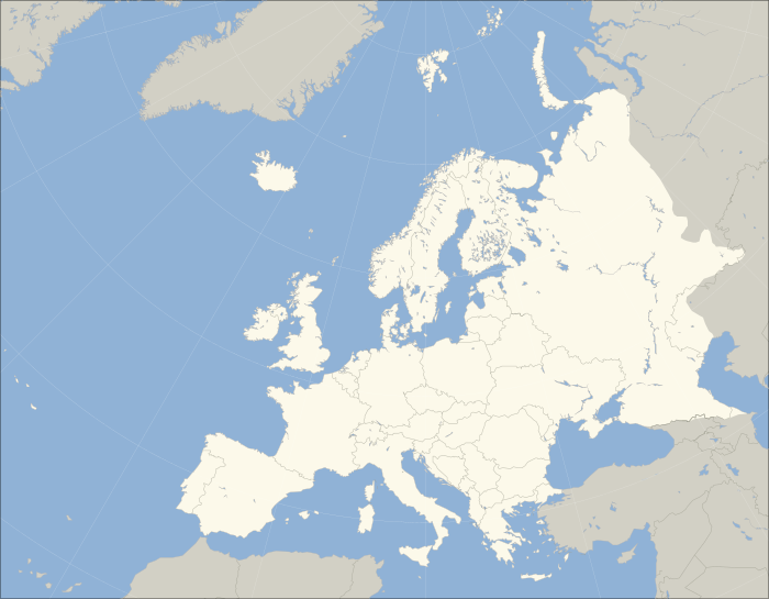
English: A blank political map of Europe. The continental boundary to Asia indicated follows the standard convention of the crest of the Greater Caucasus, the Urals River and the Urals Mountains to the Sea of Kara. |
| Date | (UTC) |
| Source | |
| Author |
|
| Other versions | Derivative works of this file: Historical Europe-Asia boundaries 1700 to 1900.png |
This map was improved or created by the Wikigraphists of the Graphic Lab (it). You can propose images to clean up, improve, create or translate as well. |
| This is a retouched picture, which means that it has been digitally altered from its original version. Modifications: fixed Caucasus crest. The original can be viewed here: Blank map of Europe (polar stereographic projection) cropped.svg:
|
I, the copyright holder of this work, hereby publish it under the following licenses:
This file is licensed under the Creative Commons Attribution-Share Alike 3.0 Unported license.
- You are free:
- to share – to copy, distribute and transmit the work
- to remix – to adapt the work
- Under the following conditions:
- attribution – You must give appropriate credit, provide a link to the license, and indicate if changes were made. You may do so in any reasonable manner, but not in any way that suggests the licensor endorses you or your use.
- share alike – If you remix, transform, or build upon the material, you must distribute your contributions under the same or compatible license as the original.

|
Permission is granted to copy, distribute and/or modify this document under the terms of the GNU Free Documentation License, Version 1.2 or any later version published by the Free Software Foundation; with no Invariant Sections, no Front-Cover Texts, and no Back-Cover Texts. A copy of the license is included in the section entitled GNU Free Documentation License.http://www.gnu.org/copyleft/fdl.htmlGFDLGNU Free Documentation Licensetruetrue |
You may select the license of your choice.
The map has been created with the Generic Mapping Tools: https://www.generic-mapping-tools.org/ using one or more of these public-domain datasets for the relief:
বাংলা ∙ English ∙ español ∙ français ∙ italiano ∙ 日本語 ∙ македонски ∙ sicilianu ∙ 中文(简体) ∙ 中文(繁體) ∙ +/− |

|
Permission is granted to copy, distribute and/or modify this document under the terms of the GNU Free Documentation License, Version 1.2 or any later version published by the Free Software Foundation; with no Invariant Sections, no Front-Cover Texts, and no Back-Cover Texts. A copy of the license is included in the section entitled GNU Free Documentation License.http://www.gnu.org/copyleft/fdl.htmlGFDLGNU Free Documentation Licensetruetrue |
Original upload log
This image is a derivative work of the following images:
- File:Blank_map_of_Europe_(polar_stereographic_projection)_cropped.svg licensed with Cc-by-sa-3.0, GFDL, GFDL-GMT
- 2011-04-10T03:22:32Z Adrignola 700x545 (1641312 Bytes) Reverted to version as of 13:44, 31 March 2010 - everyone cool down and discuss changes on the talk page, then make an update everyone can agree on
- 2011-04-08T18:51:00Z ComtesseDeMingrelie 700x545 (211693 Bytes) Reverted to version as of 01:06, 5 April 2011
- 2011-04-08T11:57:33Z Chipmunkdavis 700x545 (1641312 Bytes) Revert undiscussed changes
- 2011-04-05T01:06:25Z ComtesseDeMingrelie 700x545 (211693 Bytes) Reverted to version as of 19:46, 4 April 2011
- 2011-04-04T20:45:40Z Green, White and Gold 700x545 (1641312 Bytes) Reverted to version as of 13:44, 31 March 2010 Revert POV
- 2011-04-04T19:46:16Z ComtesseDeMingrelie 700x545 (211693 Bytes) rv. explained removal. making consistent with the page.
- 2011-04-04T18:43:01Z Green, White and Gold 700x545 (1641312 Bytes) Reverted to version as of 13:44, 31 March 2010
- 2011-04-02T05:49:39Z ComtesseDeMingrelie 700x545 (211693 Bytes) Correcting [[:en:Phasis|Phasis]] riverbank
- 2010-03-31T13:44:03Z Kmusser 700x545 (1641312 Bytes) Moldova-Ukraine border fix
- 2009-01-11T12:43:35Z Ssolbergj 700x545 (1640667 Bytes) {{Information |Description= |Source= |Date= |Author= |Permission= |other_versions= }}
- 2009-01-10T03:42:38Z Ssolbergj 700x545 (1580458 Bytes) {{Information |Description={{en|1=244}} |Source=Own work by uploader |Author=[[User:Ssolbergj|Ssolbergj]] |Date=24 |Permission= |other_versions= }}
Uploaded with derivativeFX
Captions
Add a one-line explanation of what this file represents
نقشه ساده ای از تقسیمات سیاسی قاره اروپا. این قاره سرتاسر با رنگ سفید نمایان است.
11 April 2011
1,380,920 byte
545 pixel
700 pixel
image/svg+xml
4abdc6456cb8c8e03a939922e9e6a5317a263f04
File history
Click on a date/time to view the file as it appeared at that time.
| Date/Time | Dimensions | User | Comment | |
|---|---|---|---|---|
| current | 15:37, 26 October 2014 | 700 × 545 (1.32 MB) | R8R | Have all separatists either in or out; Georgia may be a European country culturally and politically (I don't know if so), but not geographically (instead of another revert, start a discussion first) |
File usage
The following page uses this file:
Metadata
This file contains additional information, probably added from the digital camera or scanner used to create or digitize it.
If the file has been modified from its original state, some details may not fully reflect the modified file.
| Width | 700.20001 |
|---|---|
| Height | 544.77948 |