File:France 1154-en.svg

Size of this PNG preview of this SVG file: 503 × 600 pixels. Other resolutions: 201 × 240 pixels | 403 × 480 pixels | 644 × 768 pixels | 859 × 1,024 pixels | 1,405 × 1,675 pixels.
Original file (SVG file, nominally 1,405 × 1,675 pixels, file size: 527 KB)
| This is a file from the Wikimedia Commons. The description on its description page there is shown below.
|
Summary
| Description |
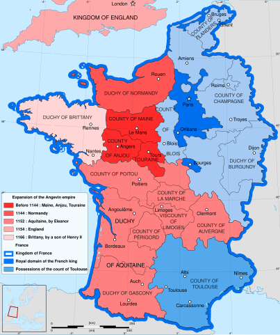
English: English map of the growth of the Plantagenet Empire, from 1144 to 1166.
Français : Carte en anglais de l'expansion de l'empire Plantagenêt, de 1144 à 1166. |
| Date | |
| Source |
Own work.Sources :
|
| Author | Reigen |
| Other versions |
[]
|


Licensing
I, the copyright holder of this work, hereby publish it under the following license:
This file is licensed under the Creative Commons Attribution-Share Alike 4.0 International license.
- You are free:
- to share – to copy, distribute and transmit the work
- to remix – to adapt the work
- Under the following conditions:
- attribution – You must give appropriate credit, provide a link to the license, and indicate if changes were made. You may do so in any reasonable manner, but not in any way that suggests the licensor endorses you or your use.
- share alike – If you remix, transform, or build upon the material, you must distribute your contributions under the same or compatible license as the original.
File history
Click on a date/time to view the file as it appeared at that time.
| Date/Time | Dimensions | User | Comment | |
|---|---|---|---|---|
| current | 15:12, 7 April 2024 | 1,405 × 1,675 (527 KB) | Jouvencel | First map was correct. Angevin Brittany was then held in vassalage to the French crown even if only nominally. Same with the County of Toulouse. |
File usage
The following page uses this file: