File:Francoprovencal-Dialect-Map-1.jpg
No higher resolution available.
Francoprovencal-Dialect-Map-1.jpg (473 × 473 pixels, file size: 194 KB, MIME type: image/jpeg)
| This is a file from the Wikimedia Commons. The description on its description page there is shown below.
|

|
This linguistic map image could be re-created using vector graphics as an SVG file. This has several advantages; see Commons:Media for cleanup for more information. If an SVG form of this image is available, please upload it and afterwards replace this template with
{{vector version available|new image name}}.
It is recommended to name the SVG file “Francoprovencal-Dialect-Map-1.svg”—then the template Vector version available (or Vva) does not need the new image name parameter. |


Summary
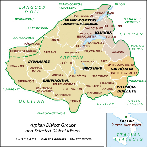
| Description | Franco-Provençal language region map showing dialects and groups (revision 1) | ||
| Date | |||
| Source | Own work (Original text: self-made, based on the text: Dalby, David (1999/2000). The Linguasphere Register of the World's Languages and Speech Communities. (Vol. 2). (Breton, Roland, Pref.). Hebron, Wales, UK: Linguasphere Press. ISBN 0-9532919-2-8 pp. 402-403) | ||
| Author | Charvex | ||
| Permission (Reusing this file) |
|
||
| Other versions | Replacement for Francoprovencal-Dialect-Map.jpg |
File history
Click on a date/time to view the file as it appeared at that time.
| Date/Time | Dimensions | User | Comment | |
|---|---|---|---|---|
| current | 10:46, 15 February 2015 | 473 × 473 (194 KB) | Savoyerli | + walliserdeustch |
File usage
The following page uses this file: