File:Globe Southwark street plan.png
No higher resolution available.
Globe_Southwark_street_plan.png (505 × 517 pixels, file size: 106 KB, MIME type: image/png)
| This is a file from the Wikimedia Commons. The description on its description page there is shown below.
|
Summary
| Description |
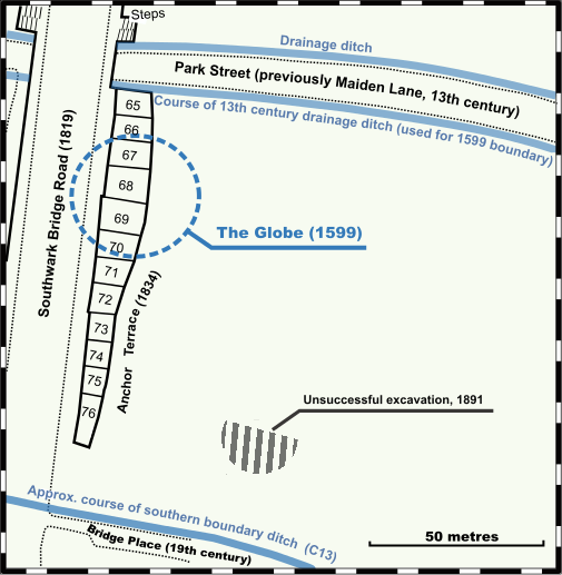
English: Position of Globe Theatre, London, relative to modern street plan. Information from The Rose and the Globe — playhouses of Shakespeare's Bankside, Southwark, ISBN 978-1-901992-85-4, pp 12; 107. Base map of Anchor Terrace is the revenue surveyors' Town Plan of London, scale 1:1056, published by Ordnance Survey 1875. Drawn by uploader using Inkscape. |
| Date | |
| Source | Own work |
| Author | Old Moonraker |
| Other versions | Converted from File:Globe Southwark street plan.svg because some text in the .svg version fails to display |
Licensing
I, the copyright holder of this work, hereby publish it under the following license:
This file is licensed under the Creative Commons Attribution-Share Alike 3.0 Unported license.
- You are free:
- to share – to copy, distribute and transmit the work
- to remix – to adapt the work
- Under the following conditions:
- attribution – You must give appropriate credit, provide a link to the license, and indicate if changes were made. You may do so in any reasonable manner, but not in any way that suggests the licensor endorses you or your use.
- share alike – If you remix, transform, or build upon the material, you must distribute your contributions under the same or compatible license as the original.
File history
Click on a date/time to view the file as it appeared at that time.
| Date/Time | Dimensions | User | Comment | |
|---|---|---|---|---|
| current | 10:53, 7 November 2011 | 505 × 517 (106 KB) | Old Moonraker |
File usage
The following page uses this file: