File:Hurricane claudette july 15 2003.jpg

Original file (5,345 × 5,345 pixels, file size: 20.23 MB, MIME type: image/jpeg)
| This is a file from the Wikimedia Commons. The description on its description page there is shown below.
|
Summary
| Description |
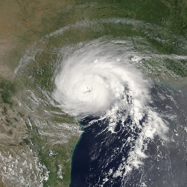
On July 15, 2003 at 12:55 EDT, the Moderate Resolution Imaging Spectroradiometer (MODIS) instrument onboard NASA’s Terra satellite captured this bird’s-eye view of Hurricane Claudette making landfall at Matagorda Bay on the middle Texas coast. At the time of this image Claudette was packing maximum sustained winds of 80 mph with slightly higher gusts, classifying the storm as a Category 1 hurricane on the Saffir-Simpson scale. Claudette is expected to dump as much as 10 inches of rain in portions of Texas and Louisiana and produce storm surge flooding of 4 to 6 feet above normal tide levels. As Claudette moves inland, she will weaken rapidly, but will continue to dump copious amounts rain on tonight (Tuesday) and tomorrow. This image was cropped from an earlier version. |
|||||
| Date | ||||||
| Source | http://visibleearth.nasa.gov/view_rec.php?id=5509 | |||||
| Author | Jacques Descloitres, MODIS Rapid Response Team, NASA/GSFC | |||||
| Permission (Reusing this file) |
|
|||||
| Other versions | Image:Hurricane Claudette 15 july 2003 1655Z.jpg |

File history
Click on a date/time to view the file as it appeared at that time.
| Date/Time | Dimensions | User | Comment | |
|---|---|---|---|---|
| current | 21:05, 23 June 2018 | 5,345 × 5,345 (20.23 MB) | TheAustinMan | Restore original curve correction and recenter |
File usage
The following page uses this file: