File:Joaquin 2015-10-01 1145z.png

Size of this preview: 600 × 600 pixels. Other resolutions: 240 × 240 pixels | 480 × 480 pixels | 768 × 768 pixels | 1,024 × 1,024 pixels | 1,600 × 1,600 pixels.
Original file (1,600 × 1,600 pixels, file size: 2.88 MB, MIME type: image/png)
| This is a file from the Wikimedia Commons. The description on its description page there is shown below.
|
Summary
| Description |
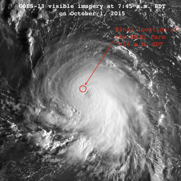
English: Visible satellite imagery of Hurricane Joaquin at 11:45 UTC October 1, 2015. The SS El Faro was lost in the hurricane around this time, with its final position reported in the northwestern eyewall. Image is slightly modified from original to include annotations. Approximate location of the SS El Faro was obtained from Reuters via WUnderground. |
| Date | |
| Source | http://www.nrlmry.navy.mil/archdat/test/kml/TC/2015/ATL/11L/visir/ |
| Author | National Oceanic and Atmospheric Administration; provided via the United States Navy |
Licensing
This image is in the public domain because it contains materials that originally came from the U.S. National Oceanic and Atmospheric Administration, taken or made as part of an employee's official duties.
|
File history
Click on a date/time to view the file as it appeared at that time.
| Date/Time | Dimensions | User | Comment | |
|---|---|---|---|---|
| current | 03:19, 10 October 2015 | 1,600 × 1,600 (2.88 MB) | Cyclonebiskit | tweak top caption |
File usage
The following page uses this file: