File:Kazakhstan COVID-19 cases map.svg

Size of this PNG preview of this SVG file: 512 × 314 pixels. Other resolutions: 320 × 196 pixels | 640 × 393 pixels | 800 × 491 pixels | 1,024 × 628 pixels | 1,280 × 785 pixels.
Original file (SVG file, nominally 512 × 314 pixels, file size: 130 KB)
| This is a file from the Wikimedia Commons. The description on its description page there is shown below.
|
Summary
| Description |
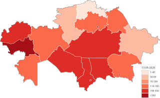
English: Map of confirmed cases of COVID-19 in administrative divisions of Kazakhstan.[1] The cities Astana, Almaty and Shymkent are represented in separate areas. Red shades represent the number of confirmed COVID-19 cases.
Confirmed 1~49
Confirmed 50~69
Confirmed 70~109
Confirmed 110~189
Confirmed 190~350
Confirmed >350 |
| Date | |
| Source | Own work |
| Author | WiLover |
Licensing
I, the copyright holder of this work, hereby publish it under the following license:
This file is licensed under the Creative Commons Attribution-Share Alike 4.0 International license.
- You are free:
- to share – to copy, distribute and transmit the work
- to remix – to adapt the work
- Under the following conditions:
- attribution – You must give appropriate credit, provide a link to the license, and indicate if changes were made. You may do so in any reasonable manner, but not in any way that suggests the licensor endorses you or your use.
- share alike – If you remix, transform, or build upon the material, you must distribute your contributions under the same or compatible license as the original.
File history
Click on a date/time to view the file as it appeared at that time.
| Date/Time | Dimensions | User | Comment | |
|---|---|---|---|---|
| current | 13:57, 13 May 2020 | 512 × 314 (130 KB) | WiLover | weekly update? |
File usage
The following page uses this file: