File:Kentucky County, Virginia 1780.png
No higher resolution available.
Kentucky_County,_Virginia_1780.png (638 × 300 pixels, file size: 222 KB, MIME type: image/png)
| This is a file from the Wikimedia Commons. The description on its description page there is shown below.
|
Summary
| Description |
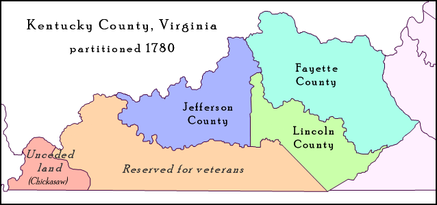
English: Map of Trans-Appalachian Virginia as it was as of mid-1780. On June 30, 1780, the Commonwealth of Virginia subdivided its Kentucky County into three new counties – Fayette, Jefferson, and Lincoln, and two unincorporated areas – one reserverd for Revolutionary War veterans and the other reserved for the Chickasaw Indians. |
| Date | |
| Source | Own work; map detail from Virginia's Western Counties 1780, Geographic Materials: Neal Hammon Series, Office of the Kentucky Secretary of State, Frankfort, Kentucky. |
| Author | Drdpw |
Licensing
I, the copyright holder of this work, hereby publish it under the following license:
This file is licensed under the Creative Commons Attribution-Share Alike 4.0 International license.
- You are free:
- to share – to copy, distribute and transmit the work
- to remix – to adapt the work
- Under the following conditions:
- attribution – You must give appropriate credit, provide a link to the license, and indicate if changes were made. You may do so in any reasonable manner, but not in any way that suggests the licensor endorses you or your use.
- share alike – If you remix, transform, or build upon the material, you must distribute your contributions under the same or compatible license as the original.
File history
Click on a date/time to view the file as it appeared at that time.
| Date/Time | Dimensions | User | Comment | |
|---|---|---|---|---|
| current | 14:41, 10 April 2018 | 638 × 300 (222 KB) | Drdpw | User created page with UploadWizard |
File usage
The following 3 pages use this file: