File:Klimagürtel-der-erde.png

Size of this preview: 800 × 400 pixels. Other resolutions: 320 × 160 pixels | 640 × 320 pixels | 1,024 × 512 pixels | 1,280 × 640 pixels | 3,600 × 1,800 pixels.
Original file (3,600 × 1,800 pixels, file size: 591 KB, MIME type: image/png)
| This is a file from the Wikimedia Commons. The description on its description page there is shown below.
|
Summary
| Description |
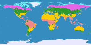
English: This map shows the Earth zones with tropical climate.
Ice cap climate Tundra climate Boreal climate Warm temperate climate Subtropical climate Tropical climate
Deutsch: Diese Karte stellt die Klimagürtel der Erde dar.
Eisklima Tundrenklima Boreales Klima Warmgemäßigtes Klima Subtropisches Klima Tropisches Klima
Ελληνικά: Αυτός ο χάρτης δείχνει τις ζώνες της γης με τροπικό κλίμα.
Πολικό κλίμα Κλίμα τούνδρας Αρκτικό κλίμα Εύκρατο κλίμα Υποτροπικό κλίμα Τροπικό κλίμα
Português: Este mapa mostra as áreas do planeta Terra com clima tropical.
Clima Polar Clima de Tundra Clima Boreal Clima Temperado Clima Subtropical Clima Tropical
Español: Este mapa muestra las zonas de la Tierra con clima tropical.
Clima Polar Clima de Tundra Clima Boreal Clima Templado Clima Subtropical Clima Tropical |
|||
| Date | ||||
| Source |
English: Own work on the basis of the following data: Deutsch: Selbst erstellt auf Basis dieser Geodaten:
|
|||
| Author | ||||
| Other versions |
|


Licensing
This file is licensed under the Creative Commons Attribution-Share Alike 3.0 Unported license.
- You are free:
- to share – to copy, distribute and transmit the work
- to remix – to adapt the work
- Under the following conditions:
- attribution – You must give appropriate credit, provide a link to the license, and indicate if changes were made. You may do so in any reasonable manner, but not in any way that suggests the licensor endorses you or your use.
- share alike – If you remix, transform, or build upon the material, you must distribute your contributions under the same or compatible license as the original.
File history
Click on a date/time to view the file as it appeared at that time.
| Date/Time | Dimensions | User | Comment | |
|---|---|---|---|---|
| current | 12:08, 24 June 2017 | 3,600 × 1,800 (591 KB) | Alatab | Costa Rican Central Valley has a Cwb clasification (Oceanic climate). |
File usage
The following page uses this file: