File:LPTA map.png

Size of this preview: 501 × 600 pixels. Other resolutions: 200 × 240 pixels | 401 × 480 pixels | 653 × 782 pixels.
Original file (653 × 782 pixels, file size: 60 KB, MIME type: image/png)
| This is a file from the Wikimedia Commons. The description on its description page there is shown below.
|

|
This map image could be re-created using vector graphics as an SVG file. This has several advantages; see Commons:Media for cleanup for more information. If an SVG form of this image is available, please upload it and afterwards replace this template with
{{vector version available|new image name}}.
It is recommended to name the SVG file “LPTA map.svg”—then the template Vector version available (or Vva) does not need the new image name parameter. |
Summary
| Description |
Português: Mapa da London Passenger Transport Area.
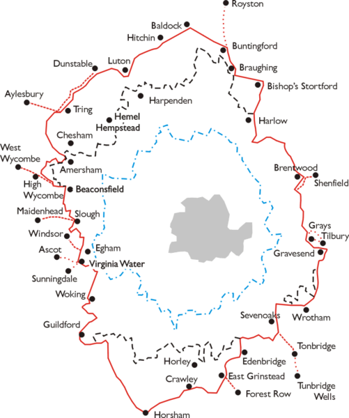
English: Map of the area of the London Passenger Transport Board 1933 - 1947. Simplified map based on leaflet issued by LPTB, July 1933. |
| Date | 26 August 2006 (original upload date) |
| Source | Transferred from en.wikipedia to Commons. |
| Author | Lozleader at English Wikipedia |
Licensing
Lozleader at the English-language Wikipedia, the copyright holder of this work, hereby publishes it under the following license:
| This file is licensed under the Creative Commons Attribution-Share Alike 3.0 Unported license. Subject to disclaimers. | ||
| Attribution: Lozleader at the English-language Wikipedia | ||
| ||
| This licensing tag was added to this file as part of the GFDL licensing update. |

|
Permission is granted to copy, distribute and/or modify this document under the terms of the GNU Free Documentation License, Version 1.2 or any later version published by the Free Software Foundation; with no Invariant Sections, no Front-Cover Texts, and no Back-Cover Texts. A copy of the license is included in the section entitled GNU Free Documentation License. Subject to disclaimers. |
Original upload log
The original description page was here. All following user names refer to en.wikipedia.
- 2006-08-26 20:03 Lozleader 653×782× (61181 bytes) Map of the area of the [[London Passenger Transport Board]] [[1933]] - [[1947]]. Simplified map based on leaflet issued by LPTB, July [[1933]]. The London Passenger Transport Area is outlined in red, with the board's "special area", in which it had a mo
File history
Click on a date/time to view the file as it appeared at that time.
| Date/Time | Dimensions | User | Comment | |
|---|---|---|---|---|
| current | 02:32, 4 May 2011 | 653 × 782 (60 KB) | Voyager | larger version |
File usage
The following page uses this file: