File:LakeUrmia SolmazDaryani00004.jpg

Size of this preview: 800 × 533 pixels. Other resolutions: 320 × 213 pixels | 640 × 427 pixels | 1,024 × 683 pixels | 1,280 × 853 pixels | 5,472 × 3,648 pixels.
Original file (5,472 × 3,648 pixels, file size: 1.98 MB, MIME type: image/jpeg)
| This is a file from the Wikimedia Commons. The description on its description page there is shown below.
|
Summary
| Description |
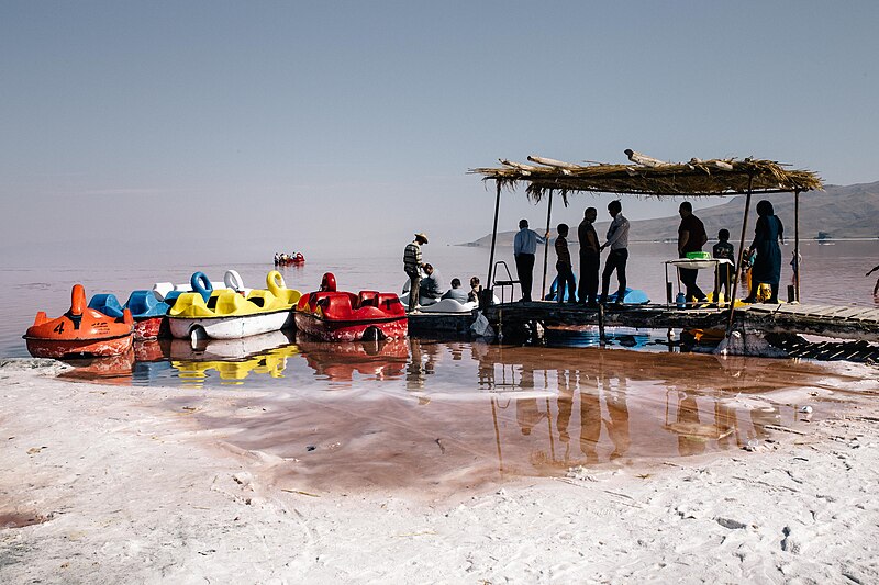
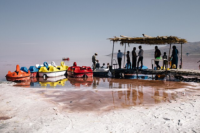
English: On holidays People come to see lake Urmia around" Shahid Kalantari" highway that still has water. The 15 km Shahid Kalantari highway is constructed by drying 85% of the boundary between the western-eastern sides of the lake. Construction of the highway has caused the northern and southern half disconnected and has made natural and fundamental changes in the hydrodynamic and ecological characteristics of the lake region. Urmia city|West-Azerbaijan|Iran |
| Date | |
| Source | Own work |
| Author | Solmaz Daryani |
| Camera location | | View this and other nearby images on: OpenStreetMap |
|---|
On holidays People come to see lake Urmia around" Shahid Kalantari" highway that still has water. The 15 km Shahid Kalantari highway is constructed by drying 85% of the boundary between the western-eastern sides of the lake. Construction of the highway has caused the northern and southern half disconnected and has made natural and fundamental changes in the hydrodynamic and ecological characteristics of the lake region. Urmia city|West-Azerbaijan|Iran ©SolmazDaryani
Licensing
I, the copyright holder of this work, hereby publish it under the following license:
This file is licensed under the Creative Commons Attribution-Share Alike 4.0 International license.
- You are free:
- to share – to copy, distribute and transmit the work
- to remix – to adapt the work
- Under the following conditions:
- attribution – You must give appropriate credit, provide a link to the license, and indicate if changes were made. You may do so in any reasonable manner, but not in any way that suggests the licensor endorses you or your use.
- share alike – If you remix, transform, or build upon the material, you must distribute your contributions under the same or compatible license as the original.
File history
Click on a date/time to view the file as it appeared at that time.
| Date/Time | Dimensions | User | Comment | |
|---|---|---|---|---|
| current | 06:57, 8 October 2019 | 5,472 × 3,648 (1.98 MB) | SolmazDaryani | User created page with UploadWizard |
File usage
The following page uses this file: