File:Lambach - Klosterplatz.JPG

Size of this preview: 800 × 434 pixels. Other resolutions: 320 × 173 pixels | 640 × 347 pixels | 1,024 × 555 pixels | 1,280 × 694 pixels | 4,606 × 2,497 pixels.
Original file (4,606 × 2,497 pixels, file size: 8.6 MB, MIME type: image/jpeg)
| This is a file from the Wikimedia Commons. The description on its description page there is shown below.
|
Summary
| Description |
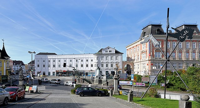
Deutsch: Der Klosterplatz der oberösterreichischen Marktgemeinde Lambach vom Stiftsportal aus gesehen.
Links im Hintergrund der Hauptplatz, davor eine Marienstatue am Beginn der Rampenauffahrt zum Stift und vis-à vis davon eine St.-Aloisius-Statue. In der Bildmitte das Ludwigerhaus (links) und das Hofrichterhaus (rechts) und vor diesem das Denkmal bezüglich den Sparkassengründern mit dem Bürgermeister Friedrich Richter im Zentrum (gegründet 1861, aufgestellt 1901). Rechts das repräsentative Sparkassengebäude, errichtet 1894. |
| Date | |
| Source | Own work |
| Author | C.Stadler/Bwag |
| Permission (Reusing this file) |
Deutsch: Hallo, du darfst mein Foto kostenlos nutzen, aber nenne mich bitte als Fotograf, beispielsweise „Foto: C.Stadler/Bwag“ oder © C.Stadler/Bwag; CC-BY-SA-4.0. Auf mehr Angaben bestehe ich nicht - im Gegensatz zu manch anderen, die die Vorgaben der unten angeführten Lizenzierung auf Punkt und Beistrich einfordern. English: Feel free to use my photos, but please mention me as the author like © C.Stadler/Bwag or © C.Stadler/Bwag; CC-BY-SA-4.0 (that's good enough) and if you want send me a message: bwag@gmx.net. |
| Camera location | | View this and other nearby images on: OpenStreetMap |
|---|
Licensing
I, the copyright holder of this work, hereby publish it under the following license:
This file is licensed under the Creative Commons Attribution-Share Alike 4.0 International license.
- You are free:
- to share – to copy, distribute and transmit the work
- to remix – to adapt the work
- Under the following conditions:
- attribution – You must give appropriate credit, provide a link to the license, and indicate if changes were made. You may do so in any reasonable manner, but not in any way that suggests the licensor endorses you or your use.
- share alike – If you remix, transform, or build upon the material, you must distribute your contributions under the same or compatible license as the original.
File history
Click on a date/time to view the file as it appeared at that time.
| Date/Time | Dimensions | User | Comment | |
|---|---|---|---|---|
| current | 13:22, 27 August 2017 | 4,606 × 2,497 (8.6 MB) | Bwag | b |
File usage
The following page uses this file: