File:Loihi 3d.gif
No higher resolution available.
Loihi_3d.gif (529 × 364 pixels, file size: 84 KB, MIME type: image/gif)
| This is a file from the Wikimedia Commons. The description on its description page there is shown below.
|
| Description |
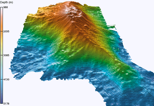
English: 3-D image of Loihi seamount after the collapse of the peak, obtained from R/V Ka'imikai-o-Kanaloa SeaBeam bathymetry taken during the LONO cruises. |
| Date | |
| Source |
(Original text: National Science Foundation / National Oceanic and Atmospheric Administration / The Hawaii Undersea Research Laboratory (HURL) http://www.soest.hawaii.edu/HURL/images/loihi_3d.gif http://www.soest.hawaii.edu/HURL/hurl_loihi.html) |
| Author | John Smith and Brooks Bays |
| Permission (Reusing this file) |
PD See [1] |
Licensing
This image is in the public domain because it contains materials that originally came from the U.S. National Oceanic and Atmospheric Administration, taken or made as part of an employee's official duties.
|
Original upload log
Transferred from en.wikipedia to Commons by Shizhao using CommonsHelper.
The original description page was here. All following user names refer to en.wikipedia.
- 2009-03-03 00:47 Resident Mario 529×364× (85757 bytes) {{Information |Description = What can you see/hear? |Source = [http://upload.wikimedia.org/wikipedia/de/4/49/Loihi_3d.gif Dutch wiki] |Date = Unstated |Author = US Gov Agencies |Permission = PD |other_versions = }}
File history
Click on a date/time to view the file as it appeared at that time.
| Date/Time | Dimensions | User | Comment | |
|---|---|---|---|---|
| current | 18:30, 25 October 2009 | 529 × 364 (84 KB) | File Upload Bot (Magnus Manske) | {{BotMoveToCommons|en.wikipedia|year={{subst:CURRENTYEAR}}|month={{subst:CURRENTMONTHNAME}}|day={{subst:CURRENTDAY}}}} {{Information |Description={{en|"3-D image of Loihi seamount after the collapse of the peak, obtained from [http://oceanexplorer.noaa.g |
File usage
The following page uses this file: