File:London Underground Overground DLR Crossrail map.svg

Size of this PNG preview of this SVG file: 800 × 422 pixels. Other resolutions: 320 × 169 pixels | 640 × 338 pixels | 1,024 × 541 pixels | 1,280 × 676 pixels | 2,500 × 1,320 pixels.
Original file (Animated SVG file, nominally 2,500 × 1,320 pixels, file size: 219 KB)
Note: Due to technical limitations, thumbnails of this file will not be animated.
| This is a file from the Wikimedia Commons. The description on its description page there is shown below.
|
Summary
| Description |
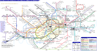
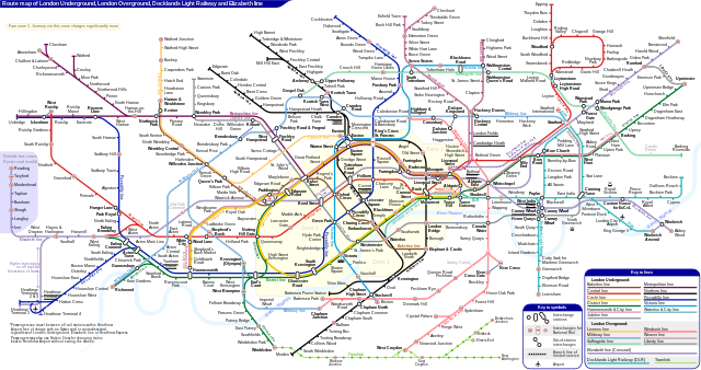
English: *Route map of London Underground, London Overground, Docklands Light Railway and Elizabeth line (Crossrail), including most green-lighted proposals.
|
|||
| Date | ||||
| Source | Own work | |||
| Author | Sameboat | |||
| Permission (Reusing this file) |
I, the copyright holder of this work, hereby publish it under the following license: This file is licensed under the Creative Commons Attribution-Share Alike 4.0 International license.
|
|||
| Other versions |
|
|||
| SVG development | This icon was created with an unknown SVG tool. This icon uses embedded text that can be easily translated using a text editor. |


|
This image is an animated SVG file. The .png preview above created by RSVG for use in Wikimedia is not animated and may be incomplete or incorrect. To see the animation, open media:London Underground Overground DLR Crossrail map.svg. It should run in any modern browser or viewer. Recent versions of Chrome, Firefox, Microsoft Edge, Safari, and Opera all support SVG animated with SMIL.
Other SVG animations can be found at Category:Animated SVG files.
|

File history
Click on a date/time to view the file as it appeared at that time.
| Date/Time | Dimensions | User | Comment | |
|---|---|---|---|---|
| current | 23:27, 24 March 2024 | 2,500 × 1,320 (219 KB) | Sameboat | change OOC icon to NR |
File usage
The following 3 pages use this file: