File:MH370 SIO search.png

Size of this preview: 782 × 600 pixels. Other resolutions: 313 × 240 pixels | 626 × 480 pixels | 1,002 × 768 pixels | 1,280 × 981 pixels | 7,461 × 5,720 pixels.
Original file (7,461 × 5,720 pixels, file size: 8.68 MB, MIME type: image/png)
| This is a file from the Wikimedia Commons. The description on its description page there is shown below.
|
Summary
| Description |
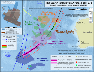
English: Map of the search areas for Malaysia Airlines Flight 370 in the Southern Indian Ocean. Note that the search areas were determined based on several factors, including drift between the date Flight 370 disappeared (8 March 2014) and the date of the search.
Not shown:
|
|||
| Date | (updated 2015-07-29) | |||
| Source |
Own work The following sources were used for data included in the map. Locations (eg. where the search was conducted, locations of satellite debris & acoustic detections) are factual information which is not subject to copyright. Most sources are noted in the map. Main map
Towed Pinger Locator path & seafloor sonar survey location:
Background:
|
|||
| Author | Andrew Heneen | |||
| Permission (Reusing this file) |
I, the copyright holder of this work, hereby publish it under the following license: This file is licensed under the Creative Commons Attribution 3.0 Unported license.
|
|||
| Other versions |
|


Licensing
I, the copyright holder of this work, hereby publish it under the following license:
This file is licensed under the Creative Commons Attribution 3.0 Unported license.
- You are free:
- to share – to copy, distribute and transmit the work
- to remix – to adapt the work
- Under the following conditions:
- attribution – You must give appropriate credit, provide a link to the license, and indicate if changes were made. You may do so in any reasonable manner, but not in any way that suggests the licensor endorses you or your use.
File history
Click on a date/time to view the file as it appeared at that time.
| Date/Time | Dimensions | User | Comment | |
|---|---|---|---|---|
| current | 18:43, 14 August 2015 | 7,461 × 5,720 (8.68 MB) | AHeneen | Fix one remaining typo (23 March2014 --> 23 March 2014) |
File usage
The following page uses this file: