File:MIdwest Invasion of 1967 map.svg

Size of this PNG preview of this SVG file: 512 × 291 pixels. Other resolutions: 320 × 182 pixels | 640 × 364 pixels | 800 × 455 pixels | 1,024 × 582 pixels | 1,280 × 728 pixels.
Original file (SVG file, nominally 512 × 291 pixels, file size: 34 KB)
| This is a file from the Wikimedia Commons. The description on its description page there is shown below.
|
Summary
| Description |
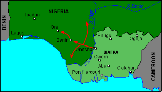
English: Approximate lines of attack used by the Biafran forces during the Midwest Invasion of 1967. The northern pincer is to Auchi and Okene, while the southern pincer is towards Sapele, Warri and Ughelli. |
| Date | |
| Source | Own work |
| Author | 141 126 210 103 account |
Licensing
I, the copyright holder of this work, hereby publish it under the following license:
This file is licensed under the Creative Commons Attribution-Share Alike 4.0 International license.
- You are free:
- to share – to copy, distribute and transmit the work
- to remix – to adapt the work
- Under the following conditions:
- attribution – You must give appropriate credit, provide a link to the license, and indicate if changes were made. You may do so in any reasonable manner, but not in any way that suggests the licensor endorses you or your use.
- share alike – If you remix, transform, or build upon the material, you must distribute your contributions under the same or compatible license as the original.
File history
Click on a date/time to view the file as it appeared at that time.
| Date/Time | Dimensions | User | Comment | |
|---|---|---|---|---|
| current | 13:52, 13 November 2019 | 512 × 291 (34 KB) | 141 126 210 103 account | User created page with UploadWizard |
File usage
The following page uses this file: