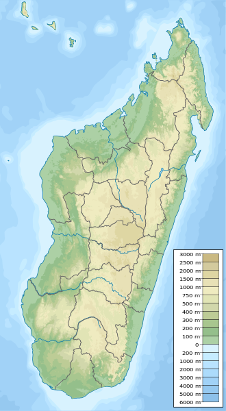
File:Madagascar physical map.svg

Size of this PNG preview of this SVG file: 330 × 600 pixels. Other resolutions: 132 × 240 pixels | 264 × 480 pixels | 422 × 768 pixels | 563 × 1,024 pixels | 426 × 774 pixels.
Original file (SVG file, nominally 426 × 774 pixels, file size: 2.2 MB)
| This is a file from the Wikimedia Commons. The description on its description page there is shown below.
|
Summary
| Description |
English: Physical map of Madagascar, parameters equal to Madagascar location map.svg. |
| Date | |
| Source | Own work |
| Author | Urutseg |
| SVG development |
Licensing
| I, the copyright holder of this work, release this work into the public domain. This applies worldwide. In some countries this may not be legally possible; if so: I grant anyone the right to use this work for any purpose, without any conditions, unless such conditions are required by law. |
File history
Click on a date/time to view the file as it appeared at that time.
| Date/Time | Dimensions | User | Comment | |
|---|---|---|---|---|
| current | 16:09, 12 May 2023 | 426 × 774 (2.2 MB) | GrandEscogriffe | adding two region borders: Atsinanana/Analanjirofo and Vatovavy-Fitovinany |
File usage
There are no pages that use this file.