File:Map of Clermont County Ohio With Municipal and Township Labels.PNG
Size of this preview: 381 × 599 pixels. Other resolutions: 152 × 240 pixels | 471 × 741 pixels.
Original file (471 × 741 pixels, file size: 58 KB, MIME type: image/png)
| This is a file from the Wikimedia Commons. The description on its description page there is shown below.
|
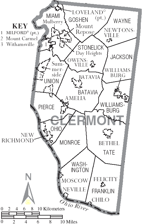
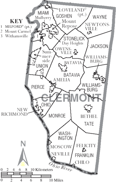
| Description | Map of Clermont County, Ohio, United States with township and municipal boundaries |
| Date | |
| Source | taken from US Census website [1] and modified by User:Ruhrfisch |
| Author | US Census, Ruhrfisch |
| Permission (Reusing this file) |
US Census / US Government work is public domain, my modifications licensed under the GNU Free Documentation License |

|
Permission is granted to copy, distribute and/or modify this document under the terms of the GNU Free Documentation License, Version 1.2 or any later version published by the Free Software Foundation; with no Invariant Sections, no Front-Cover Texts, and no Back-Cover Texts. A copy of the license is included in the section entitled GNU Free Documentation License. |
| This file is licensed under the Creative Commons Attribution-Share Alike 3.0 Unported license. | ||
| ||
| This licensing tag was added to this file as part of the GFDL licensing update. |
File history
Click on a date/time to view the file as it appeared at that time.
| Date/Time | Dimensions | User | Comment | |
|---|---|---|---|---|
| current | 13:00, 3 July 2006 | 471 × 741 (58 KB) | Ruhrfisch | {{Information| |Description= Map of Clermont County, Ohio, United States with township and municipal boundaries |Source= taken from US Census website [http://www2.census.gov/geo/maps/general_ref/cousub_outline/cen2k_pgsz/oh_cosub.pdf] and modified by [[U |
File usage
The following page uses this file: