File:Map of Masada.svg

Original file (SVG file, nominally 1,292 × 675 pixels, file size: 392 KB)
| This is a file from the Wikimedia Commons. The description on its description page there is shown below.
|
Summary
| Description |
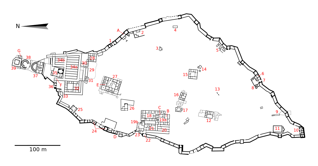
Español: Mapa mudo del yacimiento arqueológico de Masada con las estructuras más destacables numeradas (la muralla de casamatas y sus torres no se destacan al ser sus contornos evidentes):
1- Puerta del Camino de la Serpiente
22- Torre del curtido
Otros puntos de interés: A- Casamata donde se hallaron varios pergaminos עברית: מפת מצדה:
1. שער שביל הנחש. 2. בתי מגורים יהודים. 3. תאי נזירים בזנטים. 4. באר. 5. בתי מגורים יהודים. 6. מקווה. 7. השער הדרומי (שער הבאר). 8. בתי מגורים יהודים. 9. באר תת-קרקעית. 10. המצודה הדרומית. 11. באר. 12. בית אחוזה. 13. קולומבריום דמי. 14. בית מלאכה לפסיפסים. 15. בית אחוזה. 16. בית אחוזה. 17. בריכת רחצה. 18-21. הארמון המערבי: 18. אזור שירות, 19. אזור מגורים, 20. מחסנים, 21. אזור אדמיניסטרטיבי. 22. מגדל הבורסקאים 23. השער הביזנטי המערבי. 24. מגדלי קולומבריום. 25. בית כנסת 26. קפלה ביזנטית. 27. בית המשמר. 28-39. הארמון הצפוני: 28. מגורי המפקד, 29. מחצבה, 30. לשכת המפקד, 31. מגדל שמירה, 32. מבנים אדמיניסטרטיבים, 33. שער, 34. מחסנים, 35. מרחצאות, 36. שער החפיר, 37-39. ארמון הורדוס: 37. הטראסה העליונה, 38. הטראסה האמצעית, 39. הטראסה התחתונה. A. סוגר 1109, בו נמצאו קטעים ממגילת בן סירא. B. אולם הכס של הורדוס. C. פסיפס צבעוני. D. הפרצה בחומה דרכה הבקיע הצבא הרומי. E- אוצרות שקלי כסף. F. מקום מגוריהם של עולי רגל. G. מקום מציאת שלושה שלדים. |
| Date | |
| Source | Own work |
| Author | Kordas, gracias a los inestimables consejos de Chabacano |
| Camera location | | View this and other nearby images on: OpenStreetMap |
|---|
Licensing

|
Permission is granted to copy, distribute and/or modify this document under the terms of the GNU Free Documentation License, Version 1.2 or any later version published by the Free Software Foundation; with no Invariant Sections, no Front-Cover Texts, and no Back-Cover Texts. A copy of the license is included in the section entitled GNU Free Documentation License. |
- You are free:
- to share – to copy, distribute and transmit the work
- to remix – to adapt the work
- Under the following conditions:
- attribution – You must give appropriate credit, provide a link to the license, and indicate if changes were made. You may do so in any reasonable manner, but not in any way that suggests the licensor endorses you or your use.
- share alike – If you remix, transform, or build upon the material, you must distribute your contributions under the same or compatible license as the original.
File history
Click on a date/time to view the file as it appeared at that time.
| Date/Time | Dimensions | User | Comment | |
|---|---|---|---|---|
| current | 06:01, 30 March 2010 | 1,292 × 675 (392 KB) | Kordas | fixing little mistakes |
File usage
The following page uses this file: