File:Meteorological setup of the 1999 Oklahoma tornado outbreak.gif

Size of this preview: 677 × 600 pixels. Other resolutions: 271 × 240 pixels | 542 × 480 pixels | 867 × 768 pixels | 1,124 × 996 pixels.
Original file (1,124 × 996 pixels, file size: 59 KB, MIME type: image/gif)
| This is a file from the Wikimedia Commons. The description on its description page there is shown below.
|
Summary
| Description |
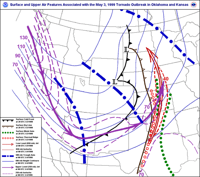
English: A map depicting surface and upper level atmospheric features associated the May 3, 1999 Tornado Outbreak in Oklahoma and Kansas. |
| Date | Unknown date |
| Source | http://www.srh.noaa.gov/images/oun/wxevents/19990503/maps/bigmapfeatures.gif |
| Author | National Weather Service Norman, Oklahoma |
Licensing
This image is in the public domain because it was stored on the web servers of the U.S. National Weather Service. NWS-created images are automatically public domain in the U.S. since the NWS is a part of the U.S. government. However, the NWS sites also host non-NWS images which have been submitted by individuals: these are generally shown as "Courtesy of ...". Such images have explicitly been released to the public domain by the copyright owner as part of the upload process.
As stated at https://www.weather.gov/fsd/disclaimer: "By submitting images, you understand that your image is being released into the public domain. This means that your photo or video may be downloaded, copied, and used by others." Thus, all* images on NWS servers are public domain (including "Courtesy of ..." and “Photo by ...” images) unless specifically stated otherwise through a copyright (©) watermark.
*A deletion discussion in November 2023 ruled that Getty Images on the web servers of NWS, are to be considered copyrighted, even without a copyright (©) watermark and are the sole exception to this rule.
|
File history
Click on a date/time to view the file as it appeared at that time.
| Date/Time | Dimensions | User | Comment | |
|---|---|---|---|---|
| current | 08:44, 14 February 2011 | 1,124 × 996 (59 KB) | Ks0stm | {{Information |Description ={{en|1=A map depicting surface and upper level atmospheric features associated the May 3, 1999 Tornado Outbreak in Oklahoma and Kansas.}} |Source =http://www.srh.noaa.gov/images/oun/wxevents/19990503/maps/bigmapfeatu |
File usage
The following page uses this file: