File:Mittlist Gfaell 02 edit.jpg

Size of this preview: 800 × 571 pixels. Other resolutions: 320 × 229 pixels | 640 × 457 pixels | 1,024 × 732 pixels | 1,280 × 914 pixels | 2,048 × 1,463 pixels.
Original file (2,048 × 1,463 pixels, file size: 2.07 MB, MIME type: image/jpeg)
| This is a file from the Wikimedia Commons. The description on its description page there is shown below.
|
|

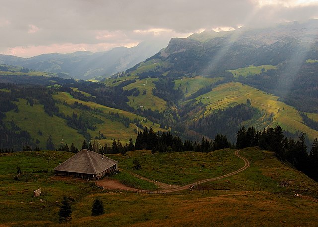
This image was selected as picture of the day on Wikimedia Commons for 10 October 2007. It was captioned as follows: English: View from the Mittlist Gfäll Alp to Schrattenflue and Chemmeribodenflue, Entlebuch region, Switzerland. Other languages:
English: View from the Mittlist Gfäll Alp to Schrattenflue and Chemmeribodenflue, Entlebuch region, Switzerland. Español: Vista desde el Mittlist Gfäll Alp a Schrattenflue y Chemmeribodenflue, región de Entlebuch, Suiza. Magyar: Látkép a Mittlist Gfäll Alpról Schrattenflue és Chemmeribodenflue felé, Svájc Entlebuch régiójában Nederlands: Gezicht vanaf de Mittlist Gfäll Alp op de Schrattenfluh en de Chemmeribodenflue in de Zwitserse Entlebuchvallei Polski: Widok z Mittlist Gfäll Alp na Schrattenflue i Chemmeribodenflue, region Entlebuch, Szwajcaria. Svenska: Utsikt från Mittlist Gfäll Alp över Schrattenflue och Chemmeribodenflue i den schweiziska regionen Entlebuch. Беларуская: Далягляд у біясферным запаведніку Энтльбух, Швейцарыя. 日本語: スイス、エントレブッフ地方のMittlist Gfäll 山からの風景 |
| Camera location | | View this and other nearby images on: OpenStreetMap |
|---|
| Description |
English: View from the Mittlist Gfäll Alp to Schrattenflue and Chemmeribodenflue, Entlebuch region, Switzerland
Deutsch: Blick von der Mittlist Gfäll Alp auf Schrattenflue und Chemmeribodenflue, Entlebuch, Schweiz
Français : Vue du Mittlist Gfäll Alp vers Schrattenflue et Chemmeribodenflue, dans la région d'Entlebuch, en Suisse.
Camera: Nikon D50Lens: AF-S DX Zoom-Nikkor 18-55 mm 1:3,5-5,6G ED |
| Date | |
| Source | Own work |
| Author | Simon Koopmann, edited by Joaquim Alves Gaspar |
| Permission (Reusing this file) |
Everybody can download it and use it for his own purposes. By publishing or other public usage of the image the author should be mentioned.
This file is licensed under the Creative Commons Attribution-Share Alike 2.0 Germany license.
 |
| Other versions |
|


File history
Click on a date/time to view the file as it appeared at that time.
| Date/Time | Dimensions | User | Comment | |
|---|---|---|---|---|
| current | 13:19, 17 August 2007 | 2,048 × 1,463 (2.07 MB) | Alvesgaspar | {{Information |Description= |Source=self-made |Date= |Author= Simonizer }} |
File usage
The following page uses this file: