File:MoonLanderLola16.png

Size of this preview: 800 × 576 pixels. Other resolutions: 320 × 230 pixels | 640 × 460 pixels | 1,024 × 737 pixels | 1,280 × 921 pixels | 3,650 × 2,626 pixels.
Original file (3,650 × 2,626 pixels, file size: 13.58 MB, MIME type: image/png)
| This is a file from the Wikimedia Commons. The description on its description page there is shown below.
|
Summary
| Description |
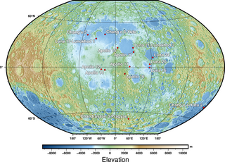
English: Position of Apollo and Lunokhod landing sites superimposed on Lunar Orbiter Laser Altimeter (LOLA) topography data using a Winkel Tripel projection |
| Date | |
| Source |
Created with GMT 4.5.6. Source: At least one of the following Public Domain data sources:
|
| Author | Zamonin |
Licensing
I, the copyright holder of this work, hereby publish it under the following license:
This file is licensed under the Creative Commons Attribution-Share Alike 4.0 International license.
- You are free:
- to share – to copy, distribute and transmit the work
- to remix – to adapt the work
- Under the following conditions:
- attribution – You must give appropriate credit, provide a link to the license, and indicate if changes were made. You may do so in any reasonable manner, but not in any way that suggests the licensor endorses you or your use.
- share alike – If you remix, transform, or build upon the material, you must distribute your contributions under the same or compatible license as the original.
File history
Click on a date/time to view the file as it appeared at that time.
| Date/Time | Dimensions | User | Comment | |
|---|---|---|---|---|
| current | 05:16, 22 September 2023 | 3,650 × 2,626 (13.58 MB) | Zamonin | new color scheme |
File usage
The following page uses this file: