File:MountTakaheMap.jpg

Size of this preview: 750 × 600 pixels. Other resolutions: 300 × 240 pixels | 600 × 480 pixels | 1,000 × 800 pixels.
Original file (1,000 × 800 pixels, file size: 139 KB, MIME type: image/jpeg)
| This is a file from the Wikimedia Commons. The description on its description page there is shown below.
|
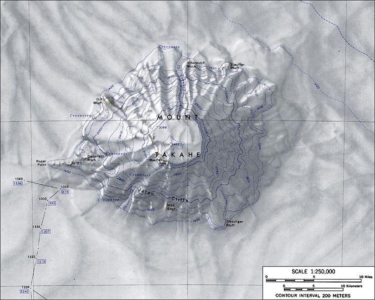
Topographic map of Mount Takahe (1:250,000 scale)
Source: http://usarc.usgs.gov/antarctic_atlas/ USGS Atlas of Antarctic Research (File:C76108s1 Ant.Map Mount Takahe.jpg)
This image is in the public domain in the United States because it only contains materials that originally came from the United States Geological Survey, an agency of the United States Department of the Interior. For more information, see the official USGS copyright policy.
|
File history
Click on a date/time to view the file as it appeared at that time.
| Date/Time | Dimensions | User | Comment | |
|---|---|---|---|---|
| current | 16:05, 16 January 2005 | 1,000 × 800 (139 KB) | GarciaB~commonswiki | Topographic map of Mount Takahe (1:250,000 scale) |
File usage
The following page uses this file: